Synopsis:
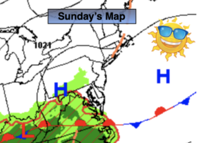
Our fine weather will continue for Sunday on this last weekend of July. The high over the region will move offshore. It’ll be bright, with comfortable readings and humidity levels. High clouds may move in during the afternoon.
Showers will move in overnight as a weak disturbance moves in.
August’s debut on Monday will feature a weak low moving just to our South. Morning showers are possible, otherwise a mix of clouds and some sun is expected.
Tuesday will be more humid as a Southerly wind takes hold. Hazy and very warm conditions are anticipated.
Haze, heat and humidity, aka the 3 h’s will return on Wednesday and Thursday as a hot West to Southwest flow develops around a strengthening Bermuda high. We most likely will be going into a heat wave.
Stay tuned.
Keep it here for a no hype, no nonsense forecast.
Sunday:
Mostly sunny. Late day high clouds. Comfortable. Highs in the lower to mid 80s. North to South winds at 5-10mph.
Tonight:
Thickening clouds. Scattered showers. Lows around 70º in urban areas, the 60s elsewhere. Southwest to Northeast at 5mph.
Monday:
Scattered morning showers possible, otherwise a mix of clouds and sun. Highs around 80º.
Tuesday:
Hazy, very warm and humid. Highs in the upper 80s to lower 90s.
Wednesday:
Hazy, hot and humid. Highs in the lower 90s.
Thursday:
Hazy, hot and humid. Highs in the mid 90s.
Catch me on the Fox Business Network from 6am to 9am Sunday and on the Fox Weather Stream until 10am. Find us on Tubi, Roku TV and YouTube TV and as always the Fox Weather App. It’s Free!