Synopsis:
As we turn the page to the new month weak low pressure will be moving offshore. Early morning showers to the East will give way to increasing sunshine during the day. It will be a cool August start with readings at least five degrees lower than average for highs. The average highs are in the mid 80s.
Tuesday will be more humid as a Southerly wind takes hold. Hazy and very warm conditions are anticipated.
Haze, heat and humidity, aka the 3 h’s will be with us through the end of the week as a hot West to Southwest flow develops around a strengthening Bermuda high. We most likely will be going into a heat wave. A scattered afternoon or evening thunderstorm is possible Friday.
Stay tuned.
Keep it here for a no hype, no nonsense forecast.
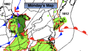
Monday:
Scattered early morning showers East, otherwise clouds giving way to some sun. Highs in the upper 70s. Northeast winds at 5mph.
Tonight:
Partly cloudy. Muggier then recent nights. Lows around 70º in urban areas, the 60s elsewhere. Southwest to South winds at 5mph.
Tuesday:
Hazy, very warm and humid. Highs in the upper 80s to lower 90s.
Wednesday:
Hazy, hot and humid. Highs around 90º
Thursday:
Hazy, hot and humid. Highs in the mid 90s.
Friday:
Hazy, hot and humid. Chance of scattered late day storms. Highs in the lower to mid 90s.
Catch me on the Fox Business Network from 6am to 9am Sunday and on the Fox Weather Stream until 10am. Find us on Tubi, Roku TV and YouTube TV and as always the Fox Weather App. It’s Free!