Synopsis:
It’ll we very warm to hot with very high humidity into early next week. This pattern is very typical for this time of the year. A West to South flow around a Bermuda high will be responsible for our conditions.
The latest computer guidance has scaled back the thunderstorm threat both today and Sunday afternoon and evening. An isolated storm is possible at that time but most of the region will remain storm-free.
Monday will be the hottest day of the bunch under abundant sunshine.
Tuesday’s late day storms are possible as a result of an approaching cool front. Tuesday should be the last of the hot days of this stretch. The front may get hung up over the region on Wednesday. If so, showers and thunderstorms will be possible. If the front is progressive, the sun will dominate and it will be less humid. Yes, relief will have arrived!
Stay tuned.
Keep it here for a no hype, no nonsense forecast.
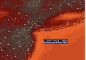
Saturday:
Hazy, very warm and humid. Chance of an isolated late day storm. Highs in the upper 80s. South to Southwest winds at 8-12mph.
Tonight:
An isolated storm, otherwise partly cloudy, very warm and muggy. Lows in the mid to upper 70s in urban areas, around 70º North and West. Light Southwest wind.
Sunday:
Hazy, hot and humid. Chance of an isolated late day storm. Highs in the around 90º.
Monday:
Hazy, hot and humid. Highs in the lower to mid 90s.
Tuesday:
Hazy, hot and humid. Chance of scattered late day storms. Highs around 90º.
Wednesday:
Clouds and sun. Chance of scattered storms. Highs in the mid 80s.
Catch me on the Fox Weather Stream from 10am-2pm on Saturday Find us on Tubi, Roku TV and YouTube TV and as always the Fox Weather App. It’s Free!