Synopsis:
It’ll be hot with very high humidity through at least tomorrow. A mix of sun and clouds is expected. This pattern is very typical for this time of the year. A West to South flow around a Bermuda high will be responsible for our conditions.
The heat will peak on Tuesday with readings possibly getting into the mid 90s.
Tuesday’s late day storms are possible as a result of an approaching cool front. Tuesday should be the last of the hot days of this stretch. The front may get hung up over the region on Wednesday. If so, showers and thunderstorms will be possible it will still be humid but not as hot.
Morning showers are possible Thursday and the front works offshore. True relief from the uncomfortable conditions should arrive by then.
Friday looks to be the best of the bunch with plenty of sunshine, seasonable temperatures and low humidity.
Stay tuned.
Keep it here for a no hype, no nonsense forecast.
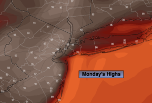
Monday:
Hazy, hot and humid. Highs in the lower to mid 90s. Southwest to South winds at 10-20mph.
Tonight:
Very warm and muggy. Lows in the upper 70s to lower 80s in urban areas, around 70º North and West. Light Southwest wind.
Tuesday:
Hazy, hot and humid. Chance of scattered late day storms. Highs in the lower to mid 90s.
Wednesday:
Clouds and sun. Not as hot, but still humid. Chance of scattered storms. Highs in the mid to upper 80s.
Thursday:
Morning showers possible. A mix of clouds and sun. Less humid and more seasonable. Highs in the mid 80s.
Friday:
Mostly sunny and comfortable. Highs in the lower 80s.
Catch me on the Fox Weather Stream from 9am-2pm on Sunday. Find us on Tubi, Roku TV and YouTube TV and as always the Fox Weather App. It’s Free!