Synopsis:
A Bermuda High will continue to supply hot air into the area-the heatwave will continue into tomorrow (Thursday will be close, as to what areas actually hit 90º, some regions may remain in the 80s). The humidity will remain at uncomfortable levels through today. The combination of high temperatures and high humidity will cause the heat index to be 100º or higher today-a Heat Advisory has been posted. A cool front will approach Thursday with spotty PM Storms. The heatwave will break by Friday.
There are questions that need to be answered for the upcoming Labor Day Weekend. A strong High will be over Southeastern Canada. This will result in a wind off the Atlantic. Readings will be much cooler Friday and Saturday. The forecast challenge is how much moisture will work in off the ocean. At this time, the forecast is for clouds and some sun with scattered showers and areas of drizzle at times Friday and Saturday. It will be a drastic change from the sunshine and heat of the last few days. It does not look like a washout. By Sunday into Labor Day Monday the pattern will break down, hopefully resulting in more sunshine but the threat of a shower cannot be ruled out.
Stay tuned.
Today:
Hazy, hot and humid. Highs in the mid 90s. Heat index: 98º-104º. Southwest winds at 8-12mph.
Tonight:
Mostly clear, very warm and muggy. Lows near 80º in the City, the 70s inland. Light Southwest wind.
Thursday:
Hazy, very warm and not as oppressively humid. Isolated afternoon storms are possible. Highs in the 80s to around 90º.
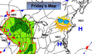
Friday:
Mostly cloudy, much cooler and less humid. Spotty showers are possible. Highs in the mid to upper 70s.
Saturday:
Mostly cloudy with scattered showers and areas of drizzle. Highs in the mid to upper 70s.
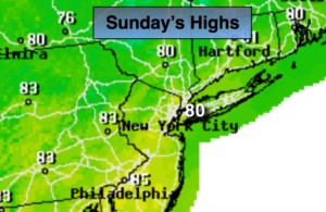
Sunday:
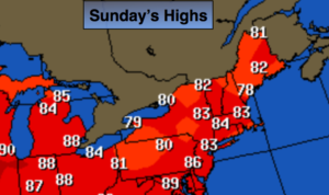
Clouds and sun. Spotty showers are possible. Warmer. Highs in the lower to mid 80s.
Keep it here for a no nonsense, no hype forecast.