Synopsis:
High pressure both at the surface and aloft will continue to influence our weather this Labor Day and into the back to school and workweek. A September heatwave could very well be on the way if three consecutive days of 90º or higher occur. The humidity will also be very high. The combination of high heat and humidity will bring the heat index up to near 100º at times through Thursday.
Relief will arrive on Friday as a cold front move through.
Stay tuned.
Labor Day:
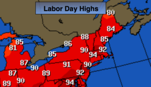
Hazy, hot and humid. Highs in the upper 80s to around 90º. Southwest winds at 5-10mph.
Tonight:
Partly cloudy, warm and muggy. Lows in the mid to upper 70s in the City, closer to 70º inland. Light Southwest wind.
Tuesday:
Hazy, hot and humid. Highs in the lower 90s. Heat index near 100º.
Wednesday:
Hazy, hot and humid. Highs around 90º. Heat index near 100º.
Thursday:
Hazy, hot and humid. Chance of an afternoon storm. Highs around 90º. Heat index near 100º.
Friday:
Mostly cloudy with scattered showers. Much cooler. Highs around 80º.
Keep it here for a no nonsense, no hype forecast.