Synopsis:
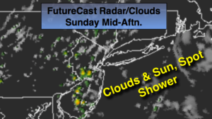
Sunday into Labor Day Monday high pressure will re-establish itself over the East coast. A mix of clouds and sun is expected. A spot shower can’t be ruled out today. Most of the time will be dry. It’ll become warmer and more humid through Labor Day as a bubble of hot air works toward the region.
A September heatwave could very well be on the way for the back to work and school week.
Stay tuned.
Today:
Clouds and sun. More humid. A spot shower is possible. Highs around 80º. Southeast winds at 5-10mph.
Tonight:
Mostly cloudy, warmer than recent nights. Lows in the lower 70s in the City, the 60s inland. Light South wind.
Labor Day:
Hazy, very warm and humid. Highs in the upper 80s.
Tuesday:
Hazy, hot and humid. Highs around 90º.
Wednesday:
Hazy, hot and humid. Highs around 90º.
Thursday:
Hazy, hot and humid. Chance of an afternoon storm. Highs around 90º.
Keep it here for a no nonsense, no hype forecast.