Synopsis:
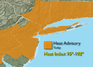
High pressure both at the surface and aloft will continue to influence our weather through Thursday. A September heatwave could very well be on the way if three consecutive days of 90º or higher occur. This might fall short as winds will be off the cooler ocean on Wednesday. The humidity will also be very high. The combination of high heat and humidity will bring the heat index up to near 100º today- a Heat Advisory has been posted for much of the area.
Scattered showers and storms are possible Thursday afternoon and evening as a cool front works toward the region.
Relief will arrive on Friday. Scattered showers are possible as the front moves to our South and slows.
Stay tuned.
Today:
Hazy, hot and humid. Highs in the lower 90s. Heat index near 95º-102º. North wind at 5mph.
Tonight:
Partly cloudy, warm and muggy. Lows in the mid in the City, the 60s inland. Light East wind.
Wednesday:
Hazy, warm and humid. Highs in the mid 80s.
Thursday:
Hazy, hot and humid. Chance of an afternoon storm. Highs around 90º.
Friday:
Mostly cloudy with scattered showers. Much cooler. Highs around 80º.
Saturday:
Clouds and sun. Cooler. Highs in the mid 70s.
Keep it here for a no nonsense, no hype forecast.