Synopsis:
One more hot and humid day will be with today. A Heat Advisory has been posted for a heat index of 96º-103º. The bubble of heat that has plagued the area for days will finally depart as a significant cool front works in later this afternoon and evening. Scattered showers and storms are possible later in the afternoon and evening as the front works toward the region.
Relief will arrive on Friday. Scattered showers are possible as the front moves to our South and slows.
The weekend right now looks much cooler with a mix of clouds and sun. There is a slight chance of showers Saturday morning, but the majority of the weekend should be dry. Temperatures will be several degrees below the average high of 80º. A Fall preview for sure.
Hurricane Florence is churning in the far Atlantic. There has been a lot of chatter of the storm coming close to the Eastern Seaboard. It is way too early for any prognostication on the track and for those saying a hit is likely somewhere along the coast, at this time, is simply a discredit to the public. We’ll continue to track. You know where to find a no hype, no nonsense forecast.
Stay tuned.
Today:
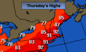
Hazy, hot and humid. Chance of an afternoon storm. Highs around 90º. Southwest 5-10mph.
Tonight:
Mostly cloudy. Chance of early storms then a chance of scattered showers. Muggy. Lows in the mid 70s in the City, the 60s inland. Winds becoming Northeast at 5-10mph.
Friday:
Mostly cloudy with scattered showers. Much cooler. Highs in the upper 70s.
Saturday:
Clouds and sun. Scattered morning showers are possible. Cooler. Highs in the mid 70s.
Sunday:
Clouds and sun. Cool. Highs in the lower 70s.
Monday:
Sun to clouds. Scattered afternoon showers. Highs in the mid 70s.
Keep it here for a no nonsense, no hype forecast.