Synopsis:
The bubble of heat that has plagued the area for days will finally depart as a significant cool front works in later this evening and tonight. Scattered showers and storms are possible into early tonight as the front works toward the region.
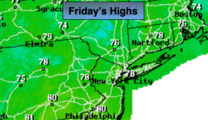
Relief will arrive on Friday. Mostly cloudy skies are expected and scattered showers are possible as the front moves to our South and slows. Readings will only be in the upper 70s (It was in the 90s today). The average high for this date is 79º.
The weekend right now looks much cooler-it’ll be a Fall preview for sure. Strong high pressure over Southeastern Canada will provide a cool flow off the Atlantic. Plenty of moisture will be to our South with a stationary front. This combination will keep skies more grey than bright. There’s a chance of showers Saturday morning, and then again Sunday afternoon-meaning there will be dry times and a bit of sun from time to time. Temperatures will be well below average and could remain in the 60s for highs on Sunday. A far cry from the heat index of 102º today!
It’ll be unsettled as we head into next week.
Hurricane Florence is churning in the far Atlantic. Many of today’s models have come in proximity to the East coast- 7 days from now. It is way too early for any prognostication on the track and for those saying a hit is likely somewhere along the coast, at this time, is simply a discredit to the public. Focusing on one model run or any track is scientifically indefensible. We’ll continue to track. You know where to find a no hype, no nonsense forecast.
Stay tuned.
Tonight:
Mostly cloudy. Chance of early storms then a chance of scattered showers. Muggy. Lows in the lower to mid 70s in the City, the upper 60s inland. Winds becoming North at 5-10mph.
Friday:
Mostly cloudy with scattered showers. Much cooler. Highs in the upper 70s. Northeast winds at 5-10mph.
Saturday:
More clouds than sun. Scattered morning showers are possible. Cooler. Highs in the lower to mid 70s.
Sunday:
Mainly cloudy. Scattered afternoon showers are possible. Very Cool. Highs in the upper 60s.
Monday:
Mostly cloudy. Scattered showers. Highs in the mid 70s.
Tuesday:
Mostly cloudy, warmer and more humid. Scattered showers. Highs in the lower 80s.
Keep it here for a no nonsense, no hype forecast.