Synopsis:.
Today will be windy behind the strengthening storm in Eastern Canada. A mix of sun and clouds is expected. It’ll be chilly.
Snow showers are possible later this evening and early tonight with a weak wave of low pressure working in from the West. Monday will be bright with slightly above average temperatures as high pressure works in from the Ohio Valley.
Tuesday will start off sunny but clouds will quickly move in. Rain and or snow is possible during the afternoon and evening. There is a low potential at this time for minor accumulations overnight Tuesday.
Wednesday will be windy and colder behind departing storm in Eastern Canada.
No outbreaks of Arctic air is expected and our snowless days continue.
Stay Tuned.
Keep it here for a no hype, no nonsense forecast.
Today:
Sun and clouds, windy and chilly. Highs around 40º. Northwest winds at 15-25mph with gusts to 35mph.
Tonight:
Snow showers early, otherwise mostly cloudy. Lows around freezing in the City, the 20s inland. Northwest to West winds decreasing to 5-10mph.
Monday:
Sun and clouds. Highs in the lower 40s.
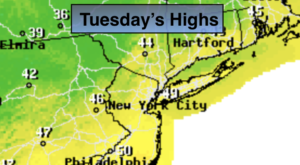
Tuesday:
Increasing clouds. Chance of rain and or snow during the afternoon. The is a low potential for a period of snow for a few hours at night. Highs in the lower 40s.
Wednesday:
Sun and clouds. Scattered flurries, windy and cold. Highs in the upper 30s.
Thursday:
Sunny. Highs around 40º.