Synopsis:.
The weekend will start off bright and mild as high pressure moves in from the Ohio Valley. On Sunday, a storm will move well West of the area. This is a warm storm track. Morning sun will give way to thickening clouds. We are now keeping it dry for the daylight hours. Rain is likely Sunday night into Monday. The rain could be heavy at times.
New Year’s Eve will be partly sunny and mild. At the stroke of midnight it will be tranquil with readings in the 30s.
As we welcome in 2020 on Wednesday ,the weather pattern will not change. It’ll be bright with readings above the average high of the upper 30s.
All of the Arctic air is banked up in Canada and no significant cold pushes are expected through the first few days of January.
Stay Tuned.
Keep it here for a no hype, no nonsense forecast.
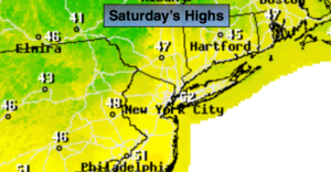
Today:
Mostly sunny. Highs in the lower 50s. Northwest winds at 5-10mph.
Tonight:
Partly cloudy.. Lows around 40º in the City, the 20 & 30s inland. Northwest winds less than 5mph.
Sunday:
Morning sun will give way to clouds. Showers are likely by evening. Highs in the upper 40s.
Monday:
Periods of rain. Highs in the mid to upper 40s.
New Year’s Eve:
Partly sunny. Highs in the mid to upper 40s.
New Year’s Day:
Partly sunny. Highs in the mid 40s.