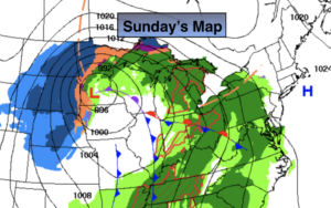
Synopsis:.
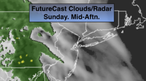
A storm will move will move across the upper plains today.Thickening clouds will be the story for our Sunday. Most of the daylight hours will be dry. With a storm track well to the West rain is expected. This is a warm scenario. Well North and West icing is possible. Rain is likely tonight into Monday. The rain could be heavy at times with over an inch expected in most areas.
New Year’s Eve will be partly sunny and mild. At the stroke of midnight it will be tranquil with readings in the 30s.
As we welcome in 2020 on Wednesday ,the weather pattern will not change. It’ll be bright with readings above the average high of the upper 30s.
All of the Arctic air is banked up in Canada and no significant cold pushes are expected through the first few days of January.
Stay Tuned.
Keep it here for a no hype, no nonsense forecast.
Today:
Thickening clouds. Showers are likely by evening. Highs in the mid 40s. Winds becoming East at 8-12mph.
Tonight:
Rain. The rain could be heavy at times late. Freezing rain is possible over the Catskills and Poconos. Lows around 40º in the City, the 30s inland. East winds at 8-12mph.
Monday:
Periods of rain. Highs in the 40s.
New Year’s Eve:
Partly sunny. Highs in the mid to upper 40s.
New Year’s Day:
Partly sunny. Highs in the mid 40s.
Thursday:
Partly sunny. Highs in the mid 40s.