Synopsis:.
Today will be grey with areas of morning fog. Low pressure will develop over the area. A few spotty showers are possible but much of the time it will be dry. It’ll be mild.
Tonight skies will clear as the low moves off the Northeast coast. A flurry is possible along with increasing winds.
Sunday will be windy behind the strengthening low in Eastern Canada. A mix of sun and clouds is expected. It’ll be chilly.
Snow showers are possible Sunday night with a weak wave of low pressure working in from the West. Monday will be bright with slightly above average temperatures as high pressure works in from the Ohio Valley.
Tuesday will start off sunny but clouds will quickly move in. Rain and or snow showers are possible during the afternoon and evening. This doesn’t look like a big deal as the developing storm over the region won’t get its act together until it well off the New England coast.
Wednesday will be windy and colder behind departing storm in Eastern Canada.
Stay Tuned.
Keep it here for a no hype, no nonsense forecast.
Saturday:
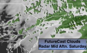
Areas of morning fog along with patchy drizzle. Cloudy for the remainder of the day. A spotty shower can’t be ruled out. Most of the time it will be dry. Mild. Highs around 50º. East to Northwest winds at 5-10mph.
Tonight:
A passing flurry or shower early, otherwise becoming mostly clear and windy. Lows in the 30s throughout. Northwest winds increasing to 15-25mph.
Sunday:
Sun and clouds, windy and chilly. Highs around 40º.
Monday:
Sun and clouds. Highs in the lower 40s.
Tuesday:
Increasing clouds. Chance of rain or snow showers during the afternoon. Highs in the lower to mid 40s.
Wednesday:
Mostly cloudy with scattered flurries. Windy and cold. Highs in the upper 30s.