Synopsis:
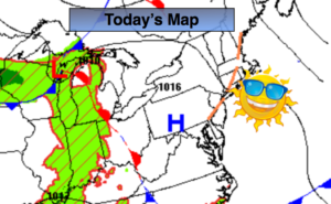
Today will be the most uncomfortable day of this warm to hot stretch. It’ll hazy, hot and humid. Scattered thunderstorms will develop as the front approaches during the afternoon. It looks like there will be two batches of storms to keep an eye to the sky to. One will be mid-day to early afternoon mainly South of the City, the other watch time for storms will be late this afternoon and evening for the entire area with the actual front. There will be dry times. and by no means will it be a washout. Some of the storms will be quite strong to isolated severe. Flash flooding is also possible.
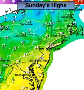
By Sunday, a refreshing airmass will move in from New England behind the passage of a cool front. The humidity will be dramatically lower. The front may get hung up and throw some clouds and possibly a few showers are way (mainly South & West of the City during the afternoon). This will be minor. Still a decent day!
The beginning and mid portion of the week will be sunny with low humidity. Readings will start off pleasant then heat up toward midweek.
Stay tuned.
Keep it here for a no nonsense, no hype forecast.
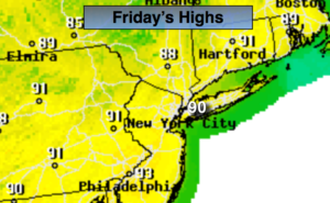
Today:
Hazy, hot and humid. Scattered afternoon storms. Highs around 90º. Heat index 95º-99º. Southwest winds at 8-15mph.
Tonight:
Scattered evening storms, otherwise partly cloudy, warm and muggy. Lows in the 70s throughout. Winds becoming Northwest at 5mph.
Sunday:
Sun and clouds, not as hot or humid. Stray showers are possible mainly South and West of the City. Highs in the lower to mid 80s.
Monday:
Sunny. Highs in the lower to mid 80s.
Tuesday:
Sunny. Highs in the upper 80s.
Wednesday:
Sunny. Highs near 90º.