Synopsis:
High pressure will continue to sit between the Mid-Atlantic coast and Bermuda this will result in very warm and humid conditions through Saturday.
A mix of sun and clouds is expected today. A weak disturbance will move in later this afternoon. Stray thunderstorms are possible. Most areas will remain rain-free.
On Saturday a cool front will approach. Ahead of the front it will be hot and humid. It’ll be the most uncomfortable day of this warm to hot stretch. Scattered thunderstorms will develop as the front approaches during the afternoon. By no means will it be a washout.
By Sunday, a refreshing airmass will move in from New England behind the passage of a cool front. The humidity will be dramatically lower. Definitely the more comfortable day of the weekend.
The beginning of the week will be sunny with low humidity and warm temperatures.
Stay tuned.
Keep it here for a no nonsense, no hype forecast.
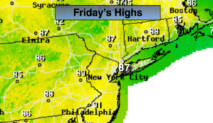
Friday:
Hazy, warm and humid. A spotty PM Storm is possible. Highs in the mid 80s. East to Southeast winds at 5-10mph.
Tonight:
A stray evening storm, otherwise partly cloudy, warm and muggy. Patchy fog. Lows in the 70s throughout. South winds under 5mph.
Saturday:
Hazy, hot and humid. Scattered afternoon storms. Highs around 90º.
Sunday:
Partly sunny, not as hot or humid. Highs in the mid 80s.
Monday:
Sunny. Highs in the mid 80s.
Tuesday:
Sunny. Highs in the mid to upper 80s.