Synopsis:
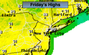
High pressure will continue to sit over the Eastern states through Saturday resulting in hot conditions. Many areas will have there first heatwave (3 consecutive days at 90º or higher). Today will be mainly sunny with a stray afternoon storm possible.
By the Saturday, a cool front will be approaching. Ahead of the front it will be hot and humid. Scattered showers and storms are possible later in the day. Some of the storms maybe severe. Keep an eye to the sky for threatening weather after 2PM.
The front should clear the coast Sunday morning allowing for a more comfortable day with lower temperatures and humidity levels.
July’s debut (on Monday) will be a winner. Mostly sunny and warm temperatures are anticipated.
Stay tuned.
Keep it here for a no nonsense, no hype forecast.
Today:
Mostly sunny. Hot. A stray afternoon or evening storm. Highs in around 90º. Winds becoming South at 5mph.
Tonight:
Partly cloudy. Warm. Lows in the lower to mid 70s in urban areas, the 60s inland. South winds under 5mph.
Saturday:.
Hazy, hot and humid. Heat index in the upper 90s. Chance of a mid to late afternoon storms. Highs around 90º.
Sunday:.
Partly sunny. Not as warm or humid. Highs in the lower to mid 80s.
Monday:.
Mostly sunny. Highs in the mid 80s.
Tuesday:.
Mostly sunny. Very warm. Highs in the mid to upper 80s.