Synopsis:
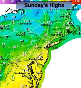
Today will be a more comfortable day with lower temperatures and humidity levels. Skies will start off sunny. Upper level energy will swing through during the afternoon. Stray showers and thunderstorms are possible with this feature. The greatest chance will be North and East of the City. This is where the upper low will be closest to. Not all areas will get in on the action.
July’s debut (on Monday) will be a winner. Mostly sunny skies and warm temperatures are anticipated.
It’ll become hot and increasingly more humid going through the holiday week as high pressure off the Mid-Atlantic coast pumps up the heat. Hazy skies are expected through Friday with a spotty afternoon storm possible on the 4th of July. Temperatures will flirt with 90º mid to late week.
Stay tuned.
Keep it here for a no nonsense, no hype forecast.
Today:.
Mostly sunny. Not as warm and becoming less humid. It’ll become breezy. Stray afternoon showers or storms are possible. The greatest threat is North and East of the City. Most areas will remain dry. Highs in the mid 80s. Northwest winds at 15-25mph with higher gusts.
Tonight:
Mostly clear. More comfortable than recents nights. Lows in the 60s in the City, the 50s inland. Northwest winds diminishing at 5-10mph.
Monday:.
Mostly sunny. Highs in the mid 80s.
Tuesday:.
Partly sunny. Very warm. Highs in the upper 80s.
Wednesday:.
Partly sunny. Very warm. Highs in the upper 80s.
4th of July:.
Hazy, hot and humid. A spotty PM Storm is possible. Highs around 90º.