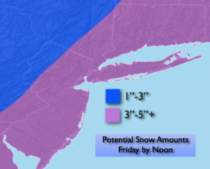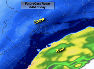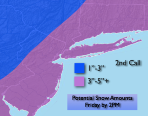
Synopsis:
A front will move into the region today. A bit of freezing rain and sleet is possible for a time during the morning just North and West of the coast. Icy spots are possible. Along the coast it will be plain rain. Readings will get above freezing later in the morning North and West and any freezing rain will go over to plain rain. There will be dry times during the afternoon. A more widespread band of light rain may develop over Southern and coastal areas later in the day with the front.
An Arctic blast is on the way for the beginning of next week. One cold front will pass through early Monday morning. Readings will only be around 30º for highs. An Arctic from will pass through Monday night. Readings on Tuesday may remain in the teens. High pressure to our West will funnel in the coldest air of the season so far from our Canadian friends. At least the sun will shine!
By Wednesday, readings will reach the freezing mark in some areas.
Temperatures will recover on Thursday as high pressure slips offshore and the airmass modifies.
Stay tuned..
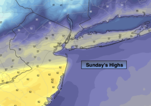
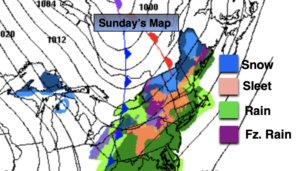
Sunday:
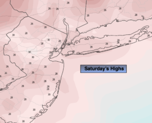
Freezing rain possible during the morning over the Northern Half of the region and just Northwest of the coast. The freezing rain will go over to scattered showers later in the morning into the early afternoon. Highs in the lower 40s. Southwest winds 8-12mph.
Tonight:
Any evening showers will give way to partly cloudy skies late. Lows in the upper 20s in the City, the lower 20s inland. Southwest to Northwest winds increasing to 15-25mph.
Monday:
Mostly sunny, breezy and cold. Highs around 30º.
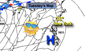
Tuesday:
Sunny and frigid. Highs only in the upper teens.
Wednesday:
Mostly sunny. Highs around 30º.
Thursday:
Mostly sunny. Seasonal. Highs around 40º.