Synopsis:
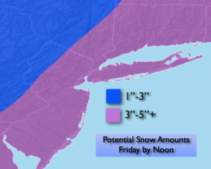
Total snowfall from the departing storm this morning looks to be 3″-5″ for much of the region. The jackpot zone looks to be Long Island and parts of Central NJ where 6+” may fall. The lighter amounts will be to the North and West as this region is farther away from the storms heavier snow. The snow will taper off from West to East this morning. The sun will return and it’ll be blustery.
A cold Friday night is on the way with readings well below freezing in all areas.
Behind this system bright but cold conditions are expected for Saturday as high pressure moves in from Canada.
Low pressure and a front will move into the region on Sunday. It’ll be milder so this will predominately be a rain event. A bit of sleet is possible North and West at the onset.
An Arctic blast is on the way for the beginning of next week. Readings will fall to around freezing on Monday for highs and not get out of the mid 20s on Tuesday. High pressure to our West will funnel in the coldest air of the season so far from our Canadian friends. At least the sun will shine!
Stay tuned..
Friday:
Early morning snow, otherwise becoming sunny and breezy. Highs in the 30s. Northwest winds at 15-25mph with higher gusts.
Tonight:
Clear, breezy and cold. Lows in the lower 20s in the City the teens inland. Northwest winds at 10-20mph.
Saturday:
Sunny. Cold. Highs around freezing.
Sunday:
Mostly cloudy. Showers likely. Highs in the lower 40s.
Monday:
Mostly sunny. Highs in the lower 30s.
Tuesday:
Sunny and frigid. Highs in the mid 20s.