Synopsis:
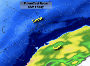
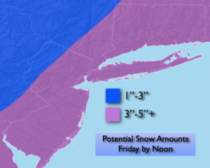
Tonight low pressure will be developing over the central Appalachians. This system will intensify and move rapidly off our coast by Friday morning. A period of snow is likely tonight into Friday morning. The latest computer models have been fairly consistent in their solutions. A 3″-5″ snowfall is likely for much of the region. The jackpot zone looks to be Eastern Long Island and Ocean county where some regions may exceed 5″. The lighter amounts will be to the North and West as this region won’t get into the moderate snow. The snow will begin between 2-4 am and taper off from West to East mid-morning to mid-day. The sun will return and it’ll be blustery.
Behind this system bright but cold conditions are expected for Saturday as high pressure moves in from Canada.
Low pressure and a front will move into the region on Sunday. It’ll be milder so this will predominately be a rain event.
An Arctic blast is on the way for the beginning of next week. Readings will fall to around freezing on Monday for highs and not get out of the mid 20s on Tuesday. High pressure to our West will funnel in the coldest air of the season so far from our Canadian friends. At least the sun will shine!
Stay tuned..
Tonight:
Snow developing after midnight from Southwest to Northeast. Lows in the lower 30s in the City the upper teens and 20s inland. North to Northeast winds at 5-10mph.
Friday:
Early morning snow, otherwise becoming sunny and breezy. Highs in the 30s. Northwest winds at 15-25mph with higher gusts.
Saturday:
Sunny. Cold. Highs around freezing.
Sunday:
Mostly cloudy. Showers likely. Highs in the lower 40s.
Monday:
Mostly sunny. Highs in the lower 30s.
Tuesday:
Sunny and frigid. Highs in the mid 20s.