
Synopsis:
Today will be seasonal. We’ll be in between systems. Sun will give way to late day clouds.
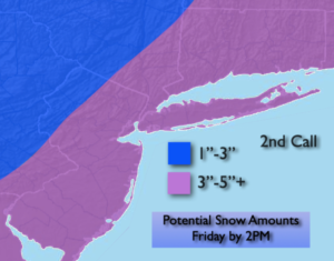
Tonight low pressure will be developing over the central Appalachians. This system will intensify and move rapidly off our coast by Friday morning. A period of snow is likely tonight into Friday morning. The latest computer models slowed the storms movement slightly and has the low a bit closer to the coast. This translates to an increase in potential snow amounts. The 2nd call map above is showing a general 3″-5″ of snow for much of the region. The jackpot zone looks to be Eastern Long Island and Ocean county where some region may exceed 5″. The snow will begin between 2-4 am and taper off from West to East mid-morning to mid-day. The sun will return and it’ll be blustery.
Behind this system bright but cold conditions are expected for Saturday as high pressure moves in from Canada.
Low pressure and a front will move into the region on Sunday. It’ll be milder so this will predominately be a rain event.
Seasonal sun is expected for Monday as a vast area of high pressure encompasses the Eastern one half of the country.
Stay tuned..
Thursday:
Mostly sunny. Late day clouds. Seasonal. Highs around 40º. West winds at 8-12mph.
Tonight:
Snow developing after midnight from Southwest to Northeast. Lows in the lower 30s in the City the upper teens and 20s inland. North to Northeast winds at 5-10mph.
Friday:
Early morning snow, otherwise becoming sunny and breezy. Highs in the 30s.
Saturday:
Sunny. Cold. Highs around freezing.
Sunday:
Mostly cloudy. Showers likely. Highs in the lower 40s.
Monday:
Partly sunny. Highs in the upper 30s.