Spectacular Saturday. Showery Sunday (PM)…

r04_icast

Synopsis:

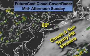
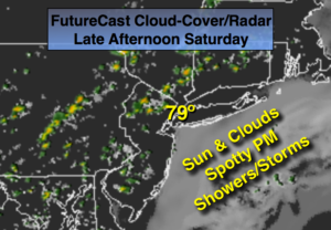
High pressure will lose it’s influence over the region this weekend-this last weekend of Summer, Fall arrives on Thursday. We’ll squeeze out one more beauty today. By Sunday a moisture laden Southerly flow ahead of a weakening cool front will produce scattered showers, mainly in the afternoon.  The showers won’t be widespread so it won’t be raining all the time.

The front will slow down on Monday continuing the threat of showers and possibly a thunderstorm.

The drought situation continues to worsen. Most areas are in a moderate to severe drought. The rainfall deficit for the year ranges from five to ten inches, with the highest deficit being over Long Island and parts of Connecticut.

Today:

Mostly sunny.  Highs will be in the mid to upper 70s. Southeast wind 10-15mph.

Tonight:

Becoming mostly cloudy. Not as cool as recent nights. Lows in the upper 60s in the City, mid 60s inland. Southwest wind at 5mph.

Sunday:

Mostly cloudy, more humid. Scattered showers, more likely during the afternoon. Highs in the upper 70s.

Monday:

Mostly cloudy with a chance of showers and thunderstorms.  Highs in the upper 70s.

Tuesday:

Partly sunny with highs in the lower 80s.

Wednesday:

Sunny with highs around 80º.

Stay Tuned.

Keep it here for a no nonsense, no hype forecast.


Fine Friday. Drought Continues to Worsen…


Synopsis:

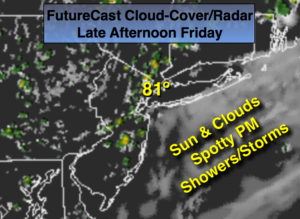
Strong Canadian high pressure will influence our weather into the first part of the weekend. Pleasant conditions are expected through Saturday. The next chance of showers won’t come until Sunday with an approaching cool front.

These high pressure systems are precluding storm development which is worsening the drought situation. Most areas are in a moderate to severe drought. The rainfall deficit for the year ranges from five to ten inches, with the highest deficit being over Long Island and parts of Connecticut.

Today:

Sunny with seasonal readings.  Highs will be in the mid to upper 70s. Southeast wind 8-12mph.

Tonight:

Clear and cool with lows in the lower 60s in the City, the upper 40s inland. Southeast wind at 5mph.

Saturday:

Mostly sunny with highs in the upper 70s.

Sunday:

Mostly cloudy with a chance of showers.  Highs in the upper 70s.

Monday:

Possible morning showers, afternoon sun.  Highs in the upper 70s.

Tuesday:

Mostly sunny with highs in the lower 80s.

Stay Tuned.

Keep it here for a no nonsense, no hype forecast.


Much Cooler Today- Fall Feel…


Synopsis:

A strong Canadian will move toward the Northeast today.  It’ll be a Fall preview for the end of the week especially after Wednesday’s high of 91º.  Pleasant conditions are expected through Saturday. The next chance of showers won’t come until Sunday afternoon with an approaching cool front.

These high pressure systems are precluding storm development which is worsening the drought situation. The forecast doesn’t look good for significant/widespread rain the next several days. An updated drought statement will be issued in the coming days.

Today:

Sunny and much cooler.  Temperatures will be in the mid 70s.  Northeast to East wind at 8-12mph.

Tonight:

Clear and very cool with lows near 60º in the City, the mid to upper 40s inland. Southeast wind at 5mph.

Friday:

Sunny with seasonal readings.  Highs will be in the mid to upper 70s.

Saturday:

Mostly sunny with highs in the upper 70s.

Sunday:

Morning sun will give way to clouds and afternoon showers.  Highs around 80º.

Monday:

Possible morning showers, afternoon sun.  Highs in the upper 70s.

Stay Tuned.

Keep it here for a no nonsense, no hype forecast.


Warm Wednesday. Dry Streak Continues…


Synopsis:

High pressure will continue to dominate our weather through today. It’ll warm up, but cool air will once again invade the region with a cool front sweeping in tonight. Another strong high pressure system will  move in for late week making it feel more like Fall.

These high pressure systems are precluding storm development which is worsening the drought situation. The forecast doesn’t look good for significant/widespread rain the next several days. An updated drought statement will be issued in the coming days.

Today:

Mostly sunny, warmer with highs in the mid to upper 80s. A stray late day storm is possible. Most areas will be storm-free. Southwest to West wind at 10-20mph.

Tonight:

Mostly clear and cool  Lows in the lower 60s in the City, the lower 50s inland. North wind at 10-20mph.

Thursday:

Sunny and much cooler.  Temperatures will be in the mid 70s.

Friday:

Sunny with seasonal readings.  Highs will be in the mid to upper 70s.

Saturday:

Mostly sunny with highs in the upper 70s.

Sunday:

Morning sun will give way to clouds and afternoon showers.  Highs around 80º.

Stay Tuned.

Keep it here for a no nonsense, no hype forecast.


A Mainly Dry, Seasonal Stretch. Warm Wednesday Bump…


Synopsis:

Strong high pressure will continue to dominate our weather through Wednesday.  This will result in pleasant readings.  Nights will be crisp-fall like.  It’ll warm up for Wednesday but the cool air will once again invade the area by weeks end with another Canadian high pressure system moving in. These high pressure systems are precluding storm development which is worsening the drought situation. The forecast doesn’t look good for significant/widespread rain the next several days.  An updated drought statement will be issued in the coming days.

Today:

Sunny.  Highs in the lower 80s.  Southwest to South wind at 10-15mph.

Tonight:

Clear and cool  Lows in the upper in the City, the upper 50s inland. Southwest wind 5mph.

Wednesday:

Partly sunny, warmer with highs in the mid to upper 80s.

Thursday:

Sunny and much cooler.  Temperatures will be in the mid 70s.

Friday:

Sunny with seasonal readings.  Highs will be in the mid to upper 70s.

Saturday:

Mostly sunny with highs near 80º.

Stay Tuned.

Keep it here for a no nonsense, no hype forecast.


More Seasonal. String of Beautiful Days on the Way…


Synopsis:

Finally a refreshing air mass has moved into the region. High pressure is of a cooler origin.  This will result in more seasonal readings with very low humidity.  Nights will be crisp-fall-like.  It’ll warm up for midweek but the cool air will once again invade the area by weeks end with another Canadian high pressure system moving in.

Today:

Sunny and seasonal with readings in the upper 70s.  Northeast to Southeast wind at 8-12mph.

Tonight:

Clear and cool  Lows in the mid 60s in the City, near 50º inland. South to Southwest wind under 5mph.

Tuesday:

Sunny.  Highs in the lower 80s.

Wednesday:

Partly sunny, warmer with highs in the mid to upper 80s.

Thursday:

Sunny and much cooler.  Temperatures will be in the mid 70s.

Friday:

Sunny with seasonal readings.  Highs will be in the mid to upper 70s.

Many areas are in a drought and the forecast doesn’t look good for significant/widespread rain the next several days.

Stay Tuned.

Keep it here for a no nonsense, no hype forecast.


Humidity Lowers Dramatically by Afternoon…


Synopsis:

A cool front will sweep through the region this morning with limited showers or storms, otherwise it’ll be mostly cloudy.  It’ll be much more comfortable by afternoon with lower humidity under mostly sunny skies and breezy conditions. High pressure will move in for the beginning of the workweek with more seasonal September readings.  A string of beauties are on the way.

Today:

Sun and clouds this morning, humid with a stray shower or storm possible. Becoming mostly sunny around mid-day with rapidly lowering humidity during the afternoon. Breezy. Highs will be reach the mid 80s.  Northwest wind at 10-20mph.

Tonight:

Clear and much cooler.  Lows in the lower to mid 60s in the City, near 50º inland. Winds will diminish out of the Northwest at 5-10mph.

Monday:

Sunny and seasonal with readings in the upper 70s.

Tuesday:

Sunny.  Highs in the lower 80s.

Wednesday:

Partly sunny, warmer with highs in the mid to upper 80s.

Thursday:

Sunny and much cooler.  Temperatures will be in the mid 70s.

Many areas are in a drought and the forecast doesn’t look good for significant/widespread rain the next several days.

Stay Tuned.

Keep it here for a no nonsense, no hype forecast.


Sizzling Saturday, Then Relief….


Synopsis:

An area of high pressure over the Southeast dominate our weather through Saturday. This high will continue to pump up a hot and humid airmass. Many areas will experience a September heat wave with readings at or above 90º on Saturday. Some areas may not have 3 consecutive days of 90º or higher, which constitutes a heat wave, but it will be uncomfortable never the less.  A Heat Advisory has been posted for central and Southern NJ through Saturday for a heat index of 98º-103º.  A cool front will sweep through Saturday night and Sunday morning with limited showers or storms.  It’ll be much more comfortable Sunday afternoon with lower humidity and temperatures.

High pressure will move in for the beginning of the workweek with more seasonal September readings.  A string of beauties are on the way.

Today:

Hazy, hot and humid with highs around 90º. A stray storm is possible, most areas will remain storm-free.  Southeast to South wind at 10-20mph.

Tonight:

Partly cloudy and muggy with spotty storms. Lows in the mid 70s in the City, around 70º inland. Winds Southwest at 10-15mph.

Sunday:

Spotty morning showers and storms otherwise becoming mostly sunny and less humid by afternoon. Highs in the mid 80s.

Monday:

Sunny and more seasonal with highs around 80º.

Tuesday:

Sunny with readings in the lower 80s.

Wednesday:

Sunny with readings in the lower 80s.

Many areas are in a drought and the forecast doesn’t look good for significant/widespread rain the next several days.

Stay Tuned.

Keep it here for a no nonsense, no hype forecast.


Heat Continues…


Synopsis:

An area of high pressure over the Southeast dominate our weather through Saturday. This high will continue to pump up a hot and humid airmass.  The potential of a late Summer September heat wave exists with readings flirting with 90º and high humidity through Saturday (some areas may not have 3 consecutive days of 90º or higher, which constitutes a heat wave, but it will be uncomfortable never the less).  The heat index will be in the 90s.  A cool front will sweep through Saturday night with limited showers or storms and a less humid Sunday.

Today:

Hazy, hot and humid with highs near 90º. Northwest to Southwest wind at 5-10mph. A spotty late afternoon or evening storm is possible.

Tonight:

Spotty early storms, otherwise partly cloudy. Lows in the mid 70s in the City, around 70º inland. Winds becoming Northeast at 5mph.

Saturday:

Hazy, hot and humid with highs around 90º. A spotty late afternoon or evening storm is possible.

Sunday:

Partly sunny and less humid with highs in the mid 80s.

Monday:

Sunny and more seasonal with highs around 80º.

Tuesday:

Sunny with readings in the lower 80s.

This is the peak of hurricane season-early to mid September.  The good news is, the tropics area quiet right now.

Stay Tuned.

Keep it here for a no nonsense, no hype forecast.
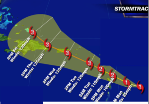


Potential September Heat Wave on the Way…


Synopsis:

An area of high pressure will develop over the Southeast through Friday. This high will pump up a hot airmass.  The potential of a late Summer September heat wave exists with readings flirting with 90º and high humidity Thursday through Saturday.  A Heat Advisory is in effect for NYC through Friday for a heat index in the mid 90s.  A cool front will sweep through Saturday night with limited showers or storms and a less humid Sunday.

Today:

Hazy, hot and humid with highs near 90º.  Winds becoming Southwest at 8-12mph.

Tonight:

Partly cloudy. Lows in the mid 70s in the City, around 70º inland. Southwest wind at 5-10mph.

Friday:

Hazy, hot and humid with highs around 90º.

Saturday:

Hazy, hot and humid with highs around 90º.

Sunday:

Partly sunny and less humid with highs in the mid 80s.

Monday:

Sunny and more seasonal with highs around 80º.

Stay Tuned.

Keep it here for a no nonsense, no hype forecast.