Synopsis:
Our June-like October weather will continue as an extensive area of high pressure remains off the coast. This will allow the bubble of warm air to remain over the region into the weekend. Readings will be at least ten degrees above average. The average high is 68º.
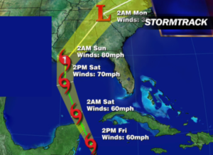
Much of the tri-state area is in a dry spell. Widespread significant rain hasn’t fallen in several weeks. The next potential of significant rain will be early next week with the remnants of a tropical system Nate working up the piedmont.
Nate is a tropical storm in the Northwest Caribbean. The storm should strengthen as it feeds off the bathtub waters of the Caribbean. Nate will be near Cancun Friday Night and then emerge into the Gulf of Mexico over the weekend. Nate should become a hurricane and make landfall over the central Gulf coast states Saturday night.
Stay tuned.
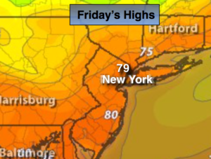
Today:
Sun and clouds. Warm. Highs approaching 80º. Northwest to Southwest winds at 5-10mph.
Tonight:
Partly cloudy and warm. Lows in the 60s throughout. Southwest wind less 5mph.
Saturday:
Mostly sunny. Warm. Highs around 80º.
Sunday:
Partly sunny, warm and humid. A spot shower is possible. Highs in the lower 80s.
Monday:
Sun and clouds. Humid. Scattered showers are possible. Highs in the upper 70s.
Tuesday:
Sun and clouds. Humid. Scattered showers are possible. Highs in the upper 70s.
Keep it here for a no nonsense, no hype forecast.