Synopsis:
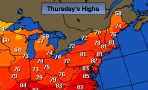
Our June-like October weather will continue as an extensive area of high pressure slips off the coast. This will allow the warmest air of the week to reach the area today on a Southwest flow. Readings will be well above average. The average high is 69º.
A weak cool front will move through the area tonight. Scattered showers are possible this evening and tonight. The front is lacking cooler air behind it so Friday will once again be ten degrees above average under a mix of sun and clouds. High pressure will move in for the weekend resulting in sunny, warm conditions.
Much of the tri-state area is in a dry spell. Widespread significant rain hasn’t fallen in several weeks. The next potential of significant rain will be early next week with the remnants of a tropical system Nate working up the piedmont.
Stay tuned.
Today:
Partly sunny and warm. Highs around 80º. A few showers are possible by evening. Southwest winds at 5-10mph.
Tonight:
Mostly cloudy and mild with scattered showers. Lows in the lower to mid 60s in the City, the upper 50s inland. Southwest to West wind 5-10mph.
Friday:
Sun and clouds. Warm. Highs approaching 80º.
Saturday:
Mostly sunny. Warm. Highs around 80º.
Sunday:
Partly sunny and warm. Highs in the upper 70s.
Monday:
Sun and clouds. Humid. Scattered showers are possible. Highs in the upper 70s.
Keep it here for a no nonsense, no hype forecast.