Synopsis:
A drier flow from the Northwest will drastically lower the humidity today. It’ll still be very warm with plenty of sunshine as high pressure noses in from Canada.
The high will move into Eastern Canada while a weak area of low pressure moves in from the Ohio Valley. This will result in mostly cloudy conditions Wednesday with showers possible by afternoon. The threat of showers will continue Wednesday night and into Thursday morning. The high will finally supply cooler, seasonal readings for mid-October. It has been an usually warm and humid time and it looks like we’ll get a break and return to more typical conditions for this time of the year.
The seasonal readings won’t last too long as the upcoming weekend looks to be much warmer as a Southwesterly flow takes hold once again.
Stay tuned.
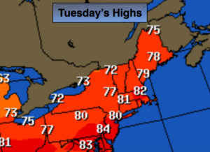
Today:
Mostly sunny. Much less humid. Highs around 80º. Northwest winds at 5-10mph.
Tonight:
Clear to partly cloudy. Much cooler than recent nights. Lows in the lower 60s in the City, the 50s inland. Northwest to Northeast winds at 5mph.
Wednesday:
Mostly cloudy with scattered afternoon showers. Highs around 70º.
Thursday:
Mostly cloudy. Scattered morning showers. Much cooler. Highs in the mid 60s.
Friday:
Partly sunny. Highs around 70º.
Saturday:
Partly sunny and warmer. Highs in the mid 70s.
Keep it here for a no nonsense, no hype forecast.