Synopsis:
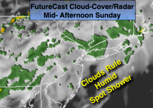
Our June-like weather in October will continue as an extensive area of high pressure remains off the coast. This will allow the bubble of warm air to remain over the region through the weekend. Readings will be at least ten degrees above average. The average high is 67º. A weak front will washout over the region resulting in mainly cloudy skies. Spotty showers are possible just about anytime with the best chance before early afternoon. It will not be a washout. It’ll be tropical with high humidity.
Much of the tri-state area is in a dry spell. Widespread significant rain hasn’t fallen in several weeks. The next potential for rain will be Monday into Monday night with the remnants of a tropical system Nate working up the piedmont. Where does the band of heaviest rain set up is the question. At this time it looks to be North and West of the City. We’ll take anything we can get.
The system will pass to the Northeast late Monday Night. Tuesday and Wednesday look dry with readings still above average. In fact, true fall conditions won’t be experienced the entire upcoming week. The cool air is locked up in Canada and won’t arrive for some time.
Nate made landfall as a category one hurricane Saturday night in Biloxi Mississippi and now is a tropical storm and weakening rapidly over the Southern states. The remnants of Nate should be felt in our area Monday and Monday Night-the rains of the dissipating storm, not damaging winds.
Stay tuned.

Today:
Mostly cloudy, warm and humid. Spotty showers. Highs in the 70s to around 80º. South/Southwest winds at 10-15mph.
Tonight:
Mostly cloudy, muggy with patchy fog. Spotty showers. Readings will be warmer than the average high for the day. Lows in the 60s to around 70º. South wind 5-10mph.
Monday:
Mostly cloudy and humid with scattered showers. Some of the rain maybe heavy later in the day and at night, especially North and West of the City. Highs in the mid 70s.
Tuesday:
Sun and clouds. Humid. Highs around 80º.
Wednesday:
Partly sunny, cooler and less humid. Highs in the lower 70s.
Thursday:
Mostly cloudy. A spot shower. Highs in the upper 60s.
Keep it here for a no nonsense, no hype forecast.