Sunny Stretch into the Weekend…

Synopsis:

Strong high pressure will move into the region today and be with us through the weekend.  It’ll start off unseasonably cool and then temperatures will once again be above average by Sunday. Picture perfect pumpkin pickin’ weather is on the way this weekend.

Today:

Sunny and chilly with readings in the lower 60s.  North wind at 10-15mph.

Tonight:

Clear and chilly.  Lows in the upper 40s in the City, near 30º inland.  Scattered frost is likely inland. Light Northeast wind.

Saturday:

Seasonal Sunshine.  Highs in the mid 60s.

Sunday:

Mostly sunny, milder.  Highs in the upper 60s.

Monday:

Sun and clouds, mild.  Stray showers are possible.  Highs around 70º.

Tuesday:

Partly sunny and warm.  Highs in the mid 70s.

Stay Tuned.

Keep it here for a no nonsense, no hype forecast.


Patchy AM Fog. Warmer, Spot PM Shower…

Synopsis:

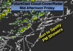
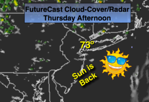
A cool front will approach the area today.  A warm southwest flow ahead of the front will result in above normal temperatures.  We’ll have to contend with areas of patchy dense fog this morning. Expect a mix of sun and clouds with spotty afternoon showers.  Not all areas will get wet.

Strong high pressure will move into the region Friday and be with us through the weekend.  It’ll start off unseasonably cool and then temperatures will once again be above average by Sunday. Picture perfect pumpkin’ picking’ weather is on the way this weekend.

Hurricane Nicole is a dangerous category 3 hurricane with winds of 125mph.  The eye of Nicole will move over or very near Bermuda today.  Godspeed to the people of that island.

Today:

Areas of AM patchy dense fog otherwise a mix of sun and clouds. Spotty afternoon showers are possible (FutureCast Cloud-Cover and Radar above).  Highs near 70. Southwest to West wind at 8-12mph.

Tonight:

Becoming mostly clear and much cooler.  Lows near 50º in the City, the upper 30s inland. Northwest wind at 10-15mph.

Friday:

Sunny and chilly with readings only around 60º.

Saturday:

Sunny, cool.  Highs in the lower 60s.

Sunday:

Mostly sunny, milder.  Highs in the mid to upper 60s.

Monday:

Sun and clouds, warm.  Stray showers are possible.  Highs around 70º.

Stay Tuned.

Keep it here for a no nonsense, no hype forecast.


Milder Mix of Sun & Clouds…

Synopsis:

High pressure will slip off the East coast today and tomorrow.  The return Southwest flow will result in milder readings.  A cold front will sweep through  Thursday night rain-free.  A second high will move in on Friday and into the weekend with cooler readings.

Today:

Sun and clouds.  Highs in the mid to upper 60s. Southeast wind at 5-10mph.

Tonight:

Partly cloudy. Not as chilly as recent nights.  Lows in the upper 50s in the City, the mid 40s inland. Light and variable winds.

Thursday:

Partly sunny and warmer with readings around 70º.

Friday:

Mostly sunny and cooler.  Highs in the lower 60s.

Saturday:

Sunny.  Highs in the lower 60s.

Sunday:

Sunny.  Highs in the mid 60s.

Stay Tuned.

Keep it here for a no nonsense, no hype forecast.


Frosty AM Inland. Abundant Cool Sunshine…

Synopsis:

High pressure systems will continue to move in from Canada the next several days.  The first high will sit over the region through early Thursday followed by a cool front Thursday night.   The second high will move in on Friday.  Dry, mainly sunny days are expected with cool nights.

Today:

Morning frost inland.  Sunny and cool with highs 60º-65º.  The average high is 66º. Light Northeast to Southeast wind.

Tonight:

Becoming partly cloudy. Lows in the lower 50s in the City, the 30s inland. Light East wind.

Wednesday:

Sun and clouds.  Highs in the mid to upper 60s.

Thursday:

Partly sunny and warmer with readings around 70º.

Friday:

Mostly sunny and cooler.  Highs in the lower 60s.

Saturday:

Mostly sunny.  Highs in the lower 60s.

Stay Tuned.

Keep it here for a no nonsense, no hype forecast.


Frost Advisory Inland. Temps in the 30s Inland…

Synopsis:

Strong high pressure will sit over the area tonight. Conditions are setting up for a frost to occur in many areas away from the coast and urban corridor tonight. With clear skies, nearly calm winds and temperatures in the 30’s scattered frost is possible.  Some areas well inland in sheltered valleys maybe around freezing at daybreak. Time to bring in those tender plants and flowers.

The week will feature plenty of sunshine as a quiet weather pattern takes hold.  Temperatures will creep up through Thursday and then drop again by Friday as another cool front pushes in.

Tonight:

Clear and chilly with scattered frost possible in colder areas. Lows in the upper 40s in the City, the 30s inland. Diminishing North wind at less than 5mph.

Tuesday:

Sunny and cool with highs 60º-65º.  The average high is 66º.

Wednesday:

Sun and clouds.  Highs in the mid to upper 60s.

Thursday:

Partly sunny and warmer with readings around 70º.

Friday:

Mostly sunny and cooler.  Highs in the lower 60s.

Saturday:

Mostly sunny.  Highs in the lower 60s.

Stay Tuned.

Keep it here for a no nonsense, no hype forecast.


Chilly Winds with Plenty of Sun to Start Workweek…

Synopsis:

Strong high pressure will build in from Canada today and supply a fresh chilled airmass to the area. Winds will be gusty, especially in the morning and then will diminish during the afternoon. Conditions are setting up for a frost to occur in many areas away from the coast and urban corridor tonight. With clear skies, nearly calm winds and temperatures in the mid 30s scattered frost is possible. Time to bring in those tender plants and flowers.

The week will feature plenty of sunshine as a quiet weather pattern takes hold.  Temperatures will creep up through Thursday and then drop again by Friday as another cool front pushes in.

Today:

Mostly sunny, breezy and cool.  North/Northwest wind at 15-25mph with gusts to 35mph this morning along the coast.  Winds will diminish this afternoon.  Highs around 60º.

Tonight:

Clear and chilly with scattered frost possible in colder areas. Lows in the upper 40s in the City, the 30s inland.  North wind at 5mph.

Tuesday:

Sunny and seasonal highs in the mid 60s.  The average high is 66º.

Wednesday:

Sunny skies.  Highs in the upper 60s.

Thursday:

Partly sunny and warmer with readings in the upper 60s.

Friday:

Mostly sunny and cooler.  Highs in the lower 60s.

Stay Tuned.

Keep it here for a no nonsense, no hype forecast.


AM Rain Coastal Areas. PM Sun West. Windy. Matthew Leaves US…

Synopsis:

The combination of Post-Cyclone Matthew moving off the Outer Banks of North Carolina and a cool front along the coast will result in an area of rain that will mainly cover the I-95 corridor Southeast to the coast today.  It’ll rain in these areas through the morning.  North and West it’ll be cloudy but mainly dry.  As the storm and front continue to move East the rain will  taper off from West to East this afternoon (FutureCast Cloud Cover & Radar above).  The skies will brighten and the sun will return inland. It’ll be windy with strong high pressure moving into the Great Lakes and the departing storm.

A dry stretch is in the making for the majority of next week with high pressure reigning supreme.  It’ll be sunny and cooler than average to start the week.

Hurricane Matthew has lost it’s characteristics and is now post-tropical and moving off the Outer Banks of North Carolina.  Record rain fell in North Carolina and winds did gust above hurricane force at the coast.  The storm will continue to weaken and move out to sea.

Today:

Rain along the coast this morning.  Cloudy inland. The rain will taper off from West to East this afternoon at the coast.  Increasing sunshine is expected inland.  Windy.  North wind at 15-30mph with gusts to 40 at the coast.  Highs in the lower 60s.

Tonight:

Becoming mostly clear.  Breezy and much cooler.  Lows in the upper 40s in the City, the lower 40s inland.  North wind at 15-25mh.

Monday:

Mostly sunny, breezy and cool.  Highs in the lower 60s.  The average high is 66º.

Tuesday:

Sunny with readings in the lower to mid 60s.

Wednesday:

Sunny and seasonal with readings in the mid 60s.

Thursday:

Partly Sunny with highs in the upper 60s.

Stay Tuned.

Keep it here for a no nonsense, no hype forecast.


Clouds For Saturday. Spot PM Shower. Sun Returns Sunday PM…

Synopsis:

The weekend forecast is looking semi-decent.  We are watching two players: a cool front and Hurricane Matthew. The FutureCast radar and cloud cover for this afternoon (map above) depicts mainly cloudy skies. A few spotty showers are possible in the afternoon and at night.  Matthew will stay well to our South and East.  Sunday will start off with clouds and maybe a few hours of coastal rain, but the day will eventually turn mostly sunny.  It’ll be breezy and cooler.

A dry stretch is in the making for the majority of next week with high pressure reigning supreme.

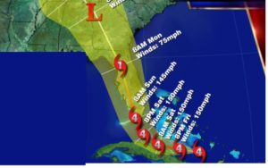
Hurricane Matthew’s winds have decreased to 75mph. The hurricane is hugging the coast of South Carolina and has made landfall just Southeast of McClellanville, SC at 11am.  Hurricane force wind gusts are likely from for Coastal South Carolina today. Hurricane Warnings are up for coastal South Carolina North to Surf City, North Carolina. Matthew will continue to slowly weaken. The storm is now moving Northeast and will be on or just off the coast of North Carolina through Sunday.  A Flooding event in unfolding in Northeastern SC and and Central and Eastern NC.  A possible loop of the Matthew will occur well off the coast into early next week as it weakens as a tropical storm.

Today:

Mainly cloudy.  A spotty afternoon shower is possible.  Highs near 70º.  East wind at 5mph.

Tonight:

Cloudy with spotty showers. A more organized area of light rain may brush coastal areas late.  Lows near in the mid to upper 50s in the City, the lower 50s inland.  Winds becoming North and increasing late at 10-20mph.

Sunday:

Morning clouds.  A bit of light rain may skirt the coast in the morning.  Becoming sunny during the afternoon from West to East. Breezy. Cooler with highs in the mid 60s.

Monday:

Sunny with readings in the lower to mid 60s.

Tuesday:

Sunny and seasonal with readings in the mid 60s.

Wednesday:

Sunny with highs in the mid to upper 60s.

Stay Tuned.

Keep it here for a no nonsense, no hype forecast.


Sunny, Warm Close to Workweek. Matthew Along Florida Coast…

Synopsis:

An area of high pressure will sit over the Northeast today.  Sunny and pleasant conditions are expected. Temperatures will be above normal- in the 70s.

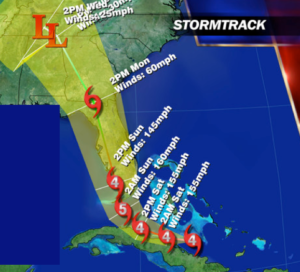
Hurricane Matthew is category 3 storm with winds of 115mph. The hurricane continues to parallel the Northeast coast of Florida, just offshore.  Hurricane force wind gusts are likely from Daytona and to the North as the hurricane makes its closest approach the coast. Hurricane Warnings are up for the East coast of Florida from Cocoa Beach, Fl, North to Surf City, South Carolina. Matthew will continue to slowly weaken. The Western Atlantic high pressure will keep the hurricane from going out to sea for Florida .  But once it’s at the latitude of Georgia it will start it’s curvature to the East.  How sharp of a curvature will determine if the Georgia through North Carolina coast line will see hurricane force winds or tropical storm force winds.   The storm will affect this region over the weekend.  The trough never looked sharp enough to have Matthew ride up the Mid-Atlantic or Northeast coast. A possible loop of the hurricane will occur well off the coast.

Only a few scattered showers are expected around here late Saturday with the trough swinging through with its accompanied cold front.  Fall will be in here in full force Sunday with cooler and breezy conditions.

095334w5_nl_sm

Today:

Sunny.  Highs in the mid 70s.  East to Southeast wind at 5-10mph.

Tonight:

Clear early, becoming mostly cloudy late.  Lows near 60º in the City, the mid 40s inland.  Light East wind.

Saturday:

More clouds than sun.  A spotty afternoon shower is possible.  Highs in the upper 60s.

Sunday:

Mostly sunny, breezy and cool with highs in the mid 60s.

Monday:

Sunny and cool with readings in the lower to mid 60s.

Tuesday:

Sunny and seasonal with readings in the mid 60s.

Stay Tuned.

Keep it here for a no nonsense, no hype forecast.
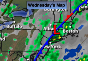


Sunny Stretch Through Friday. Matthew Heading Toward Florida…

Synopsis:

An area of high pressure will sit over the Northeast for the rest of the week.  Sunny and pleasant conditions are expected through Friday. Temperatures will be above normal- in the 70s.

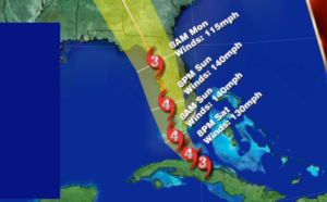
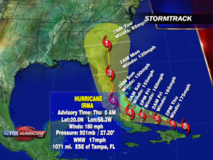
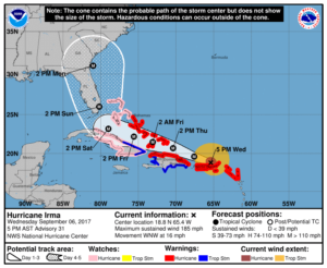
Hurricane Matthew is a catastrophic category 4 storm with winds of 140mph. The Northwest Bahamas will feel the wrath of Matthew through Friday and very likely a damaging scenario is will occur for the island chain (map below).  The potential track continues to take the storm to the coast of Florida and the Southeastern States North to North Carolina Thursday through Saturday.  A direct hit in any of these states remains to be seen. But nonetheless, Hurricane Warnings are up for the East coast of Florida from Ft. Lauderdale North to Edisto Beach, South Carolina. This area has a high chance of seeing damaging winds.  The Western Atlantic high pressure will keep the hurricane from going out to sea for Florida . The trough never looked sharp enough to have Matthew ride up the Mid-Atlantic or Northeast coast.  Nearly all the computer models have the storm making a sharp right hand turn out to sea or swing it back around doing a loop to the South Sunday into early next week. Only a few scattered showers are expected late Saturday with the trough swinging through with its accompanied cold front.

Today:

Sunny, warm.  Highs in the mid 70s.  Northeast to Southeast wind at 5mph or less.

Tonight:

Clear and Chilly.  Lows around 60º in the City, the lower 40s inland.  East wind at 5mph or less.

Friday:

Sunny.  Highs in the lower 70s.

Saturday:

Partly Sunny.  A spotty late day shower is possible.  Highs in the upper 60s.

Sunday:

Mostly sunny, breezy and cool with highs in the mid 60s.

Monday:

Sunny and cool with readings in the mid 60s.

Stay Tuned.

Keep it here for a no nonsense, no hype forecast.