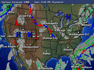
Synopsis:
A spot shower this evening otherwise, it will become mostly clear. It’ll be a Fall preview this weekend as a large, cool high pressure system works into the region from Canada. Plenty of sunshine is expected with readings five to eight degrees below average for the highs. There’ll be a nip in the air during the night.
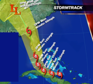
Hurricane Irma is a dangerous category 4 hurricane. Winds are sustained at 155mph as of this writing. The storm is currently moving along the North coast of Cuba. The hurricane will continue to move West Northwest and ride just offshore or may graze the Northern coast of Cuba tonight. Irma should maintain at least a category 4 or 5 status during this time frame with winds of 145mph+. Slight weaken is possible with any interaction with Cuba.
Now to Florida. Most of the computer models put the Irma as a dangerous cat 4 or 5 near the Southern tip of Florida by late Saturday Night. The combination of a weak upper low over the Southern states and a strong ridge of high pressure near Bermuda will result in the storm taking a dramatic Northerly turn. Where that turn specifically occurs is still up in the air. Will it be heading North just to the East of Fl, directly up the peninsula inland, or off the West coast of Florida? Questions that still need to be answered. The time is now to be prepared for a POSSIBLE landfalling dangerous hurricane in Florida. The map below is the National Hurricane Center track. Much can happen to the anticipated track between now and then. A difference of 50 miles could mean the difference between damaging hurricane force winds or gusts just shy of hurricane force. The cone of uncertainty is shrinking. This raises the confidence of Florida experiencing direct affect from Irma. Flooding rains and storm surge will be of great concern.
The hurricane track now looks to take the decaying hurricane into Georgia as a tropical storm. The risk to the Carolina’s has been greatly diminished.
Will our area feel any affects from Irma? At this point showers may move up from the remnants midweek.
Stay Tuned.
Tonight:
Mostly clear and very cool. Lows in the upper 50s in the City, the upper 40s inland. North wind less than 5mph.
Saturday:
Mostly sunny. Highs around 70º. North to Northeast winds at 5-10mph.
Sunday:
Sunny. Highs in the lower 70s.
Monday:
Mostly sunny. Highs in the lower to mid 70s.
Tuesday:
Partly sunny. Highs in the lower to mid 70s.
Wednesday:
Mostly cloudy with scattered showers. Highs in the lower to mid 70s.
Keep it here for a no nonsense, no hype forecast.