
Synopsis:
As we head back to work on today it’ll feel more like August with readings well into the 80s with higher humidity. High pressure off the Southeast coast will pump up the warm airmass under hazy skies. A slow moving front will basically stall for a time along the East coast causing on and off showers and possible storms tonight, Wednesday and into Thursday morning. It’ll be significantly cooler.
The front will push offshore later Thursday with the sun returning by afternoon. Cool sunny days are expected for the close of the workweek into the weekend.
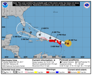
Hurricane Irma is now a extremely dangerous category 5 hurricane. Winds are sustained at 180mph as of this writing. Irma is now the strongest hurricane in the Atlantic basin recorded in National Hurricane Center history outside the Caribbean Sea and Gulf of Mexico. The storm looks to track over the Northeastern Leeward islands tonight and be near the Virgin Islands and Puerto Rico tomorrow. Whether these islands get a direct hit is yet to be seen but the hurricane will be perilously close, so at a minimum some affects will be felt.
The storm will continue to move along the Southern edge of a high pressure system in the Atlantic. This will cause Irma to track on the Northern shore or just off the coast of the Dominica Republic, Haiti and Cuba Thursday through Saturday. The hurricane should maintain at least a category 4 status during this time frame with winds of 140mph+.
Now to Florida. Most of the computer models put the Irma as a dangerous cat 4 near the Southern tip of Florida by Saturday Night. The high gives way and loosens it grip on the storm. This allows the storm to take a dramatic Northerly turn. Where that turn specifically occurs is still up in the air. Will it be heading North just to the East of Fl, directly up the peninsula inland, or off the West coast of Florida? Questions that still need to be answered. The time is now to be prepared for a POSSIBLE landfalling dangerous hurricane in Florida. The first map below is the National Hurricane Center track. The second map is the Euro Ensembles (51 tracks, essentially the spaghetti plot for the European model from the overnight run). The North turn will happen, now we have to continue to ingest the data to specifically find and when and where. Irma is still 4 days away from making the North turn. Much can happen to the anticipated track between now and then. Forecasting track errors can be quite large for 4-5 days away.
Stay Tuned.

Today:
Hazy, warm and humid. Highs in the mid 80s. Southwest winds at 10-20mph with higher gusts.
Tonight:
Scattered showers and isolated storms. Lows around 70º in the City, the 60s inland. Southwest winds at 5-10mph.
Wednesday:
Cloudy with showers. Highs in the lower 70s.
Thursday:
Morning showers, some afternoon sun. Highs in the lower 70s.
Friday:
Mostly sunny. Highs in the lower 70s.
Saturday:
Sunny. Highs around 70º
Keep it here for a no nonsense, no hype forecast.