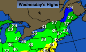
Synopsis:
A strong storm over the Canadian maritimes and high pressure over the Midwest will result in a gusty Northwest wind and cold readings today under a mix of sun and clouds. Readings will only be in the 30s to around 40º. The average high temperature is 55º.
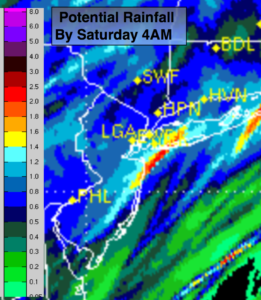
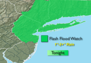
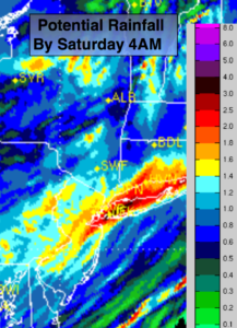
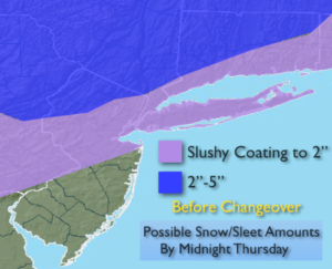
Another storm will affect the area Thursday (toward midday) into Friday morning. The models develop a storm over the Southeast and move it up the coast. The latest computer guidance continues with the idea that high pressure will funnel in cold air from New England Thursday into early Thursday night. At the same time, a decent amount of precipitation will working in from the South with the advancing storm. A mix of wet snow, sleet and rain will develop Thursday afternoon and continue into the night. The precipitation will come down heavy at times for the first few hours. The mix will go over to rain Thursday night along the coast and then inland. The potential is there for an accumulation of snow and sleet before the changeover. A few inches of snow/sleet is possible. The highest amounts will be over far Northwestern NJ, the Poconos and Upstate NY. The map above are the potential amounts. It’ll become breezy overnight as the storm nears.
By Friday the rain will taper off by midday as the storm moves up the coast.
The weekend will be chilly with a decent amount of sunshine.
You know where to find a no hype, no nonsense forecast.
Stay tuned.
Today:
Mostly sunny, breezy and cold. Highs only in the 30s to around 40º. Northwest winds at 15-25mph, diminishing later in the day.
Tonight:
Clouds early tonight will give way to partly cloudy skies. Breezy and cold. Lows in the upper 20s in the City, the teens and 20s inland. Northwest to Northeast winds less than 5mph.
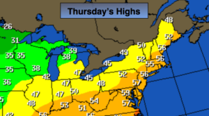
Thursday:
Any morning sun will rapidly give way to thickening clouds. Wet snow, sleet and rain will move in during the late morning and midday hours. The precipitation could come down heavy at times for a hew hours. Most areas North of a Trenton-Sandy Hook-Montauk Point line will see frozen precipitation for a few hours. Cold. Highs only in the 30s.
Friday:
Morning rain, a mix possible well inland. The sun may return for a time during the afternoon. Highs in the mid 40s.
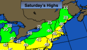
Saturday:
Mostly sunny and chilly. Highs in the upper 40s.
Sunday:
Mostly sunny and chilly. Highs in the mid 40s.
Keep it here for a no nonsense, no hype forecast.