Synopsis:
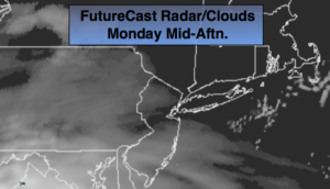
Today will start off with plenty of sunshine. High pressure will slip off the coast, this will allow moisture to work up from the South. High clouds will filter out the sun during the afternoon (map above). Temperatures will be a several degrees below the average of 55º.
A low will move up the Eastern Seaboard tonight into Tuesday. More rain is on the way. The rain will begin later this evening and continue through the morning on Tuesday. The rain will most likely end by midday and some afternoon sun is possible.
Wednesday will be windy and cold with readings only in the 30s to around 40º-a Winter feel for sure.
The latest computer guidance have converged on a solution regarding the next low to affect the area. The models have a storm developing over the Southeast and moving up the coast. The timing has now sped up. The storm looks to affect the area Thursday afternoon into Friday. At this point it looks mainly to be rain.
You know where to find a no hype, no nonsense forecast.
Stay tuned.
Today:
Morning sun, afternoon clouds. Highs in the upper 40s to around 50º. South to Southwest winds at 5-10mph.
Tonight:
Rain developing by late evening. Lows in the mid 40s in the City, the 30s inland. West winds under 5mph.
Tuesday:
Morning rain, some afternoon sun is possible. Highs in the lower to mid 50s.
Wednesday:
Mostly sunny, breezy and cold. Highs only in the 30s to around 40º.
Thursday:
Morning sun, afternoon clouds. Rain will move in later in the day. Chilly. Highs in the lower to mid 40s.
Friday:
Rain likely. Highs in the upper 40s.
Keep it here for a no nonsense, no hype forecast.