Synopsis:
Today, the return flow around a Western Atlantic high will cause temperatures to skyrocket into the 70s. It’ll be cooler at the coast. Morning clouds will give way to sun. An isolated thunderstorm is possible during the evening as a weak disturbance moves through.
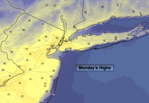
Monday will feature a Summer preview with readings soaring into the lower to mid 80s.
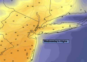
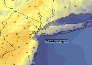
Tuesday and Wednesday will not be as warm. There is a chance of afternoon showers on Tuesday with weak low pressure moving through. Wednesday will be brighter and pleasant. Both days will have a wind off the cooler Atlantic.
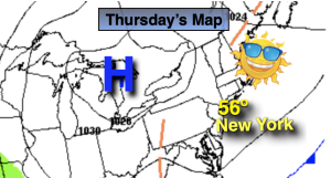
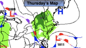
High pressure will build over the region on Thursday resulting in abundant sunshine and mild readings.
Stay tuned.
Keep it here for a no nonsense, no hype forecast.
Sunday:
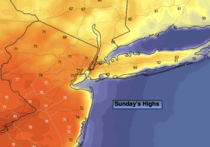
Clouds to sun. Warmer. Isolated evening storms. Highs in the mid 70s. South to Southwest winds at 5-10mph.
Tonight:
Spotty evening storms, otherwise mostly cloudy. Mild. Lows in the lower 60s in the City, the upper 50s inland. Light Southwest to West winds.
Monday:
Mostly sunny. Warm. Highs in the lower to mid 80s.
Tuesday:
Mostly cloudy. Scattered afternoon showers possible. Not as warm. Highs in the upper 60s.
Wednesday:
Partly sunny. Highs in the upper 60s.
Thursday:
Mostly sunny. Highs in the lower 70s.