Synopsis:
Clouds will dominate Wednesday as a weak cool front moves through the region. Spotty showers are in the forecast, but much of the time it will be dry. It’ll be mild.
Tonight will be cold with readings inland dropping to freezing or below.
Cooler conditions are expected Thursday as a Canadian airmass pays a short visit. It’ll be a similar forecast for Friday and Saturday as offshore high pressure dominates.
By Sunday, the return flow around the Western Atlantic high will cause temperatures to skyrocket into the 70s.
Stay tuned.
Keep it here for a no nonsense, no hype forecast.
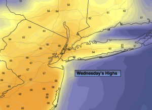
Wednesday:
Mostly cloudy. Spot shower. Mild. Highs in the mid to upper 60s. Southwest to Northwest winds at 8-15mph with gusts to 25mph.
Tonight:
Becoming clear and cold. Lows in the upper 30s to around 40º in the City, the upper 20s and 30s inland. North winds at 10-20mph.
Thursday:
Sunny. Cooler. Highs in the mid 50s.
Friday:
Sunny. Highs around 60º.
Saturday:
Partly sunny. Highs in the lower 60s.
Sunday:
Partly sunny. Warmer. Highs in the mid 70s.