Synopsis:
High pressure will move offshore today. Any sun will give way to clouds. It’ll be cool with the cloud cover. Readings will be around five degrees below the average high of 66º. A spot shower is possible later in the day and evening.
By Sunday, the return flow around the Western Atlantic high will cause temperatures to skyrocket into the 70s. An isolated thunderstorm is possible during the evening as a weak disturbance moves through.
Monday will feature a Summer preview with readings soaring into the lower 80s.
Tuesday and Wednesday will not be as warm, but it will still be mild. There is a chance of afternoon showers on Tuesday with weak low pressure moving through. Wednesday will be bright and pleasant.
Stay tuned.
Keep it here for a no nonsense, no hype forecast.
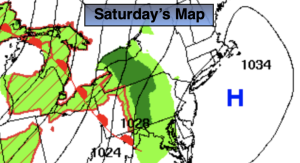
Saturday:
Sun to clouds. Chance of a spotty late day or evening shower. Highs in the lower 60s. South winds at 8-12mph.
Tonight:
Mostly cloudy. Scattered showers. Lows in the 40s throughout. Light South winds.
Sunday:
Clouds to sun. Warmer. Highs in the mid 70s.
Monday:
Mostly sunny. Warm. Highs in the lower 80s.
Tuesday:
Mostly cloudy. Afternoon showers. Not as warm. Highs in the lower 70s.
Wednesday:
Mostly sunny. Highs around 70º.