Synopsis:
A warm front will approach today with Grey skies and areas of drizzle or showers. Temperatures will still be above average.
On Tuesday, ahead of a cold front, it will be warm with periods of rain.
More seasonal temperatures are expected for the later half of the workweek as colder high pressure moves in from Canada.
Looking down the pike no snowstorms are on the map at least through the next seven days.
Stay tuned.
Today:
Cloudy with areas of drizzle or spotty showers. Highs in the mid to upper 40s. East wind at 5mph.
Tonight:
Mostly cloudy with areas of drizzle or patchy light rain. Mild. Lows in 40’s throughout. Southeast winds 5-10mph with higher gusts at the coast.
Tuesday:
Rain through early afternoon. Some late afternoon sun. Mild. Highs in the mid 50s.
Wednesday:
Partly sunny. Colder. Highs in the upper 30s.
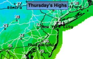
Thursday:
Partly sunny. Cold. Highs in the mid 30s.
Friday:
Sunny. Seasonal. Highs in the mid to upper 30s.
Keep it here for a no nonsense, no hype forecast.