Synopsis:
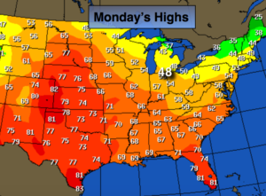
A warm Southerly flow will develop today ahead of a cold front. Temperatures will be ten to fifteen degrees warmer than average. We may flirt with 60º. The average high is 47º. The flow from the South will be moist. On and off showers and drizzle will develop later this morning under a mostly cloudy sky.
The cold front will cross the area tonight with a period of steadier rain. The computer models have now sped up the speed of the front so it looks like Wednesday morning will be rain free with the exception of showers over Eastern sections early in the morning. Skies will clear and temperatures will drop from the 50s just after midnight to the 40s during the day. This will be the start of the major pattern change to colder that will take hold for some time to come. Will a storm form along the Eastern Seaboard? The latest computer guidance has a couple of areas of weak low pressure off the coast- one Friday Night and the other later Saturday and Saturday Night. I’ve included the chance of snow showers at this point for Saturday. Still several days to watch how this plays out.
Stay tuned.
Today:
Mostly cloudy with scattered showers and areas of drizzle. Much warmer. Highs in the 50s to lower 60s. Southeast to South winds at 10-20mph with higher gusts.
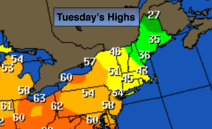
Tonight:
Showers. Warm to start with readings in the 50s. Temperatures will drop into the 40s once the front moves through late. South to West winds at 10-20mph with higher gusts.
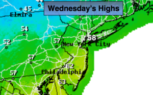
Wednesday:
Early clouds and showers East giving way to mostly sunny skies. Highs in the 40s.
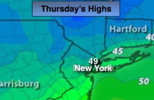
Thursday:
Partly sunny, colder. Highs in the lower 40s.
Friday:
Sun to clouds. Highs around 40º.
Saturday:
Mostly cloudy. Scattered snow showers. Highs in the upper 30s.
Keep it here for a no nonsense, no hype forecast.