Synopsis:
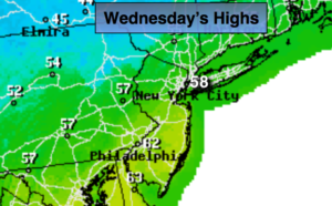
Today will feel like Spring with readings nearly ten degrees above average. The average high is 49º. The map above tells the story on how warm the areas is. All of the cold air is bottled up in Northern Canada. The reason, the jet stream is zonal meaning from West to East. This setup never brings true cold air in from Canada. Skies will be mainly sunny as high pressure remains the dominate feature through Thursday.
Two weak cool fronts will move through the area uneventful. One tonight and the second will move through early Friday-the first day of December with showers before dawn.
No major storms are in sight and the weekend looks pleasant with seasonal readings.
Stay tuned:
Today:
Mostly sunny and mild. Highs around 60º. West to Northwest winds at 10-20mph.
Tonight:
Mostly clear. Colder than recent nights. Lows in the mid 30s in the City, the 20s inland. Northwest to Northeast winds at 5mph.
Thursday:
Partly sunny, cooler with highs in the upper 40s.
Friday:
Partly sunny, breezy. Highs in the around 50º.
Saturday:
Sunny. Highs in the upper 40s.
Sunday:
Partly sunny. Highs near 50º.
Keep it here for a no nonsense, no hype forecast.