Synopsis:
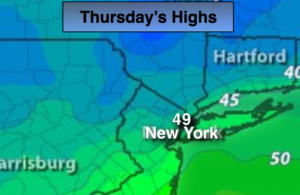
Yesterday was a day out of Spring with readings in the 60s. A cold front has moved through the region and temperatures will cool down significantly. Under partly sunny skies seasonal readings are anticipated today. The average high is 49º.
A second front will move through early Friday-the first day of December with showers before dawn. The sun will rule on Friday. There is still remains no arctic air in the country. Seasonal to above average readings are expected for the next several days as high pressure dominates.
No major storms are in sight but a major pattern change looks to be on the way for midweek next week. Much colder air will spill into the area.
Stay tuned.
Today:
Sun and clouds, cooler with highs in the upper 40s to near 50º. Northeast to Southeast winds at 5mph.
Tonight:
Mostly cloudy with a few showers. Milder than recent nights. Lows in the mid 40s in the City, the 30s inland. South to Northwest winds at 5-10mph.
Friday:
Partly sunny, breezy. Highs in the lower 50s.
Saturday:
Sunny. Highs in the upper 40s.
Sunday:
Partly sunny. Highs near 50º.
Monday:
Partly sunny. Highs near 50º.
Keep it here for a no nonsense, no hype forecast.