Synopsis:
As the holiday weekend comes to a close a chill will be with us. It’ll be a far cry from the upper 50s of Saturday. Partly sunny skies can be expected along with a busy wind. Highs will remain below average. The average high is 50º. Wind chills will remain in the 30s to around 40º.
As we return to work and school the week looks tranquil. In fact, mild readings will once again be with us by mid-week. Skies will be mainly sunny as high pressure remains the dominate feature.
Looking down the pike. Some of the compute models develop a storm on a front later Friday and into the weekend. Many days to watch how this MAY play out, but don’t hold your breath.
Stay tuned.
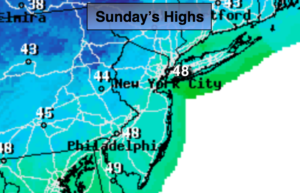
Today:
Partly sunny, breezy and cooler with highs in the upper 40s. Northwest wind 15-25mph with gusts up to 30mph.
Tonight:
Partly cloudy. Lows in the mid to upper 30s in the City, the 20s inland. West wind diminishing to 5-10mph.
Monday:
Sunny and seasonal. Highs around 50º.
Tuesday:
Sunny and mild. Highs in the mid 50s.
Wednesday:
Mostly sunny and mild. Highs in the upper 50s.
Thursday:
Partly sunny. Readings will remain above average. Highs in the lower 50s.
Keep it here for a no nonsense, no hype forecast.