Synopsis:
Areas North and West of the urban corridor experienced a freeze or frost last night as Canadian high pressure settled over the region. Today will be bright but cool. Readings will be about ten degrees below the average high of the lower 70s. Temperatures will rebound some on Friday as high pressure slips off the Northeast coast. It’ll be a fine finish to the week.
The threat of showers continues for Saturday. The combination of weak offshore low pressure and an approaching cool front will be responsible for the damp potential. The shower threat is a low one but remains in the forecast.
Sunday will be the better half of the weekend with abundant sunshine and mild readings as high pressure takes the stage.
Pleasant conditions will continue for the beginning of the week.
Keep it here for a no nonsense, no hype forecast.
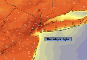
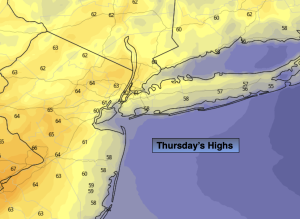
Thursday:
Sunny. Highs in the lower 60s. Northeast to Southeast winds at 8-15mph.
Tonight:
Clear. Not as cold as last night. Lows around 50º in the City, the 40s inland. South winds at 5mph.
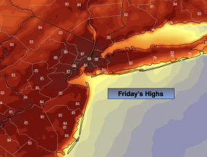
Friday:
Mostly sunny. Highs around 70º.
Saturday:
Mostly cloudy. Chance of showers. Highs around 70º.
Sunday:
Sunny and mild. Highs in the mid to upper 70s.
Monday:
Sunny. Highs in the mid 70s.