Synopsis:
Cooler readings are expected for the rest of the week as Canadian high pressure takes control. The sun will dominate. Readings will be several degrees below the average high of the lower 70s.
The next threat of showers will come Saturday. The combination of weak offshore low pressure and an approaching cool front will be responsible for the damp potential. The shower threat is a low one but remains in the forecast.
Sunday will be the better half of the weekend with abundant sunshine and mild readings as high pressure takes the stage.
Keep it here for a no nonsense, no hype forecast.
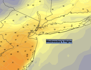
Wednesday:
Sunny, breezy and cooler. Highs in the mid 60s. Northwest winds at 15-25mph.
Tonight:
Clear and quite chilly. Lows in the mid 40s along the urban corridor, near 30º well inland with a freeze possible. Northwest winds at 10-20mph early then diminishing to 5mph.
Thursday:
Sunny. Highs in the mid 60s.
Friday:
Mostly sunny. Highs around 70º.
Saturday:
Mostly cloudy. Chance of showers. Highs around 70º.
Sunday:
Sunny and mild. Highs in the mid to upper 70s.