Synopsis:
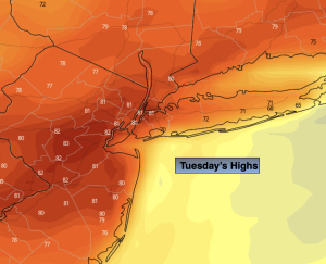
Temperatures will pop on Tuesday ahead of a cool front under a mostly sunny sky. Many areas will be flirting with 80º.
Cooler readings are expected for the rest of the week as Canadian high pressure takes control. The sun will dominate. Readings will be several degrees below the average high of the lower 70s.
The next threat of showers will come Saturday. The combination of weak offshore low pressure and an approaching cool front will be responsible for the damp potential. Confidence in Saturday’s forecast at this time is low. Stay tuned.
Keep it here for a no nonsense, no hype forecast.
Tuesday:
Sunny. Warmer. Highs around 80º. West to Southwest winds at 10-20mph.
Tonight:
Mostly clear. Lows in the mid 50s along the urban corridor, the 40s inland. West to Northwest wind at 10-20mph.
Wednesday:
Sunny, breezy and cooler. Highs in the mid 60s.
Thursday:
Sunny. Highs in the mid 60s.
Friday:
Mostly sunny. Highs around 70º.
Saturday:
Mostly cloudy. Shower threat. Highs around 70º.