Still Mild & Bright for Thursday…


Synopsis:

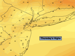
High pressure will move well off the coast resulting in a wind off the water today. Temperatures will come down from the 80s of the last two days, but readings will still be several degrees above the average high of around 70º. It will be another delightful day

The next chance of showers will come Friday with a moist flow coming up from the South. It will not be a washout.

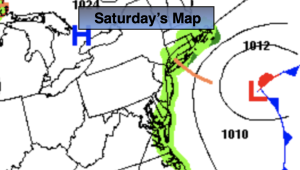
A season changer is on the map for the weekend. Saturday’s weather will be influenced by a deepening trough of low pressure in the upper levels, an approaching cold front and low pressure developing along that front. All of this will result in scattered showers for Saturday with more seasonable readings. Much cooler readings will greet us on Sunday. Highs may not get out of the 50s! Autumn will be in full force. Cool readings with sunshine will continue into Columbus Day.

Stay tuned.

Keep it here for a no nonsense, no hype forecast.

Thursday:

Mostly sunny. Highs in the mid 70s. Cooler at the coast. Southeast to East winds at 5mph.

Tonight:

Becoming mostly cloudy. Lows in the lower 60s in the City, the 50s inland. Light East winds.

Friday:

Mostly cloudy. A few showers possible. Highs around 70º.

Saturday:

On and off showers likely. Highs in the upper 60s.

Sunday:

Partly sunny, much cooler. Highs in the upper 50s.

Columbus Day:

Partly sunny. Cool. Highs around 60º.

Wednesday Warmth. Summer Feel…


Synopsis:

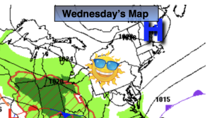
It’ll be a Summer feel today with readings well above average as strong high pressure with a bubble of warmth continues to influence the area. The average high is around 70º. Readings will be at least ten degrees to above that.

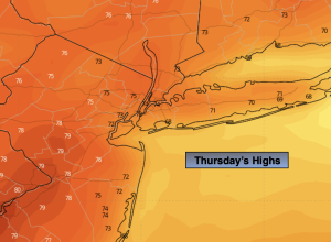
On Thursday, the high will move well off the coast resulting in a wind off the water. Temperatures will come down some under a bright sky, but above average readings will continue.

The next chance of any showers will come Friday afternoon with a moist flow coming up from the South.

A season changer is on the map for the weekend. Saturday’s weather will be influenced by a deepening trough of low pressure in the upper levels, an approaching cold front and low pressure developing along that front. All of this will result in scattered showers for Saturday with more seasonable readings. Much cooler readings will greet us on Sunday. Highs may not get out of the 50s! Autumn will be in full force.

Stay tuned.

Keep it here for a no nonsense, no hype forecast.

Wednesday:

Sunny. Warm. Highs in the lower 80s. Northeast to Southeast winds at 5mph.

Tonight:

Clear. Lows in the lower to mid 60s in the City, the 50s inland. Light Southeast winds.

Thursday:

Mostly sunny. Highs in the mid 70s.

Friday:

Clouds, some sun. A few showers possible. Highs in the lower 70s.

Saturday:

On and off showers likely. Highs in the upper 60s.

Sunday:

Partly sunny, much cooler. Highs in the upper 50s.

Late June Feel. Abundant Sunshine…


Synopsis:

A string of beauties will be with us through Thursday as strong high pressure dominates! Readings will be well above average and cross over the 80º today and Wednesday in many areas. The average high is around 70º. It’ll feel more like late June. It’s a simple forecast and one that will make most smile.

The next chance of any showers will come Friday afternoon with a moist flow coming up from the South.

A season changer is on the map for the weekend. Saturday’s weather will be influenced by a deepening trough of low pressure in the upper levels, an approaching cold front and low pressure developing along that front. All of this will result in on and off rain for Saturday with more seasonable readings. Much cooler readings will greet us on Sunday. Highs may not get out of the 50s! Autumn will be in full force.

Stay tuned.

Keep it here for a no nonsense, no hype forecast.

Tuesday:

Sunny. Warm. Highs in the lower 80s. West to South winds at 5mph.

Tonight:

Clear. Mild. Lows in the mid 60s in the City, the 50s inland. Light winds.

Wednesday:

Sunny. Warm. Highs in the lower 80s.

Thursday:

Mostly sunny. Highs in the mid 70s.

Friday:

Clouds, some sun. A few showers possible. Highs in the lower 70s.

Saturday:

On and off rain likely. Highs in the mid to upper 60s.

Bright & Warm…


Synopsis:

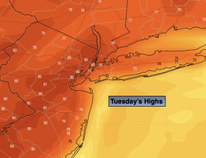
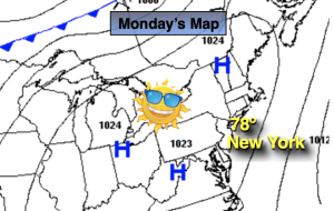
A string of beauties will be with us through Thursday at least as strong high pressure dominates! Readings will be well above average and cross over the 80º mark midweek. The average high is around 70º. It’s a simple forecast and one that will make most smile.

The next chance of any showers will come Friday with a moist flow coming up from the South.

Stay tuned.

Keep it here for a no nonsense, no hype forecast.

Monday:

Sunny. Highs in the upper 70s. Northeast winds at 5-10mph.

Tonight:

Clear. Lows in the mid 60s in the City, the 50s inland. Light and variable winds.

Tuesday:

Sunny. Warm. Highs in the lower 80s.

Wednesday:

Sunny. Warm. Highs in the lower 80s.

Thursday:

Mostly sunny. Highs in the mid 70s.

Friday:

Clouds, some sun. A few showers possible. Highs in the lower 70s.

October Delight…


Synopsis:

We will be rewarded after the deluge and dreary weather of the past few days. October’s debut will be spectacular with abundant sunshine and temperatures about five degrees above average. The average highs are in the lower 70s. A string of beauties are expected well into next week as strong high pressure dominates! Simple forecast and one that will make most smile.

Stay tuned.

Keep it here for a no nonsense, no hype forecast.

Sunday:

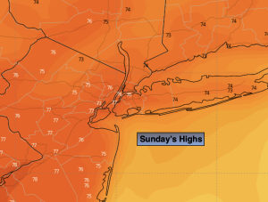
Sunny. Warmer. Highs in the mid 70s. North winds at 5-10mph.

Tonight:

Clear. Lows in the lower 60s in the City, near 50º inland. North winds less than 5mph.

Monday:

Sunny. Highs in the upper 70s.

Tuesday:

Sunny. Warm. Highs around 80º.

Wednesday:

Sunny. Highs in the upper 70s.

Thursday:

Mostly sunny. Highs in the mid 70s.

Scattered Showers. Late Day Sun?


Synopsis:

Yesterday’s storm that gave the region up to nine inches of rain in Valley Stream, Long Island (thats over two months worth of rain in ten hours) is meandering off the coast. A few rain bands from the system will spin back to the coast today. There will be on and off showers. Many areas will remain dry to the South and West of the City. If we’re lucky the sun will make an appearance later today. Readings will be several degrees below the average high of the lower 70s.

We will be rewarded as October’s debut on Sunday looks spectacular with abundant sunshine and above average temperatures. The average highs are in the lower 70s. A string of beauties are expected well into next week as strong high pressure dominates!

Stay tuned.

Keep it here for a no nonsense, no hype forecast.

Saturday:

On and off showers. A bit of late day sun is possible. Highs in the mid 60s. North winds at 10-15mph.

Tonight:

Becoming mostly clear. Lows in the upper 50s in the City, near 50º inland. North winds at 5mph.

Sunday:

Sunny. Warmer. Highs in the mid 70s.

Monday:

Sunny. Highs in the upper 70s.

Tuesday:

Sunny. Highs in the upper 70s.

Wednesday:

Sunny. Highs in the mid to upper 70s.

Areas of Severe Flooding Today. Rain. Locally Heavy…


Synopsis:

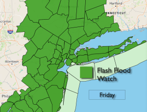
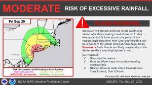
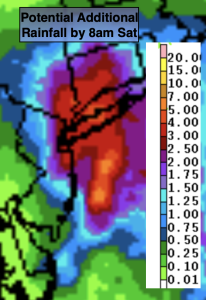
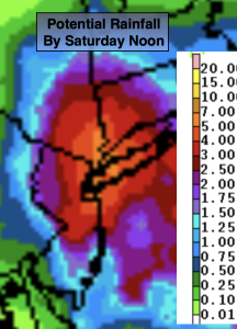
There is a moderate threat of severe flooding in and around the NYC vicinity today . Low pressure off the coast, along with a trough extending into our region will result in on and off rain through Saturday morning. Some of the rain will be locally heavy. The heaviest axis of rain, with the latest computer guidance and radar trends, looks to be in and around the NYC vicinity. The potential for one to three inches with locally up to six inches of rain is on the table. This is a perilous situation. The ground is completely saturated from previous rain early this week. It won’t take much for flooding to occur. A Flash Flood Watch has been posted for the area. If you encounter a flooded roadway- turn around, don’t drown.

Saturday will start off with clouds and the possibility of morning showers as once again we have a stubborn exiting low pressure. If we’re lucky we’ll get to see some late day sun.

October’s debut on Sunday looks spectacular with abundant sunshine and above average temperatures. The average highs are in the lower 70s. A string of beauties are expected well into next week!

Stay tuned.

Keep it here for a no nonsense, no hype forecast.

Friday:

On and off rain. Locally heavy. Highs around 60º. Northeast winds at 8-15mph.

Tonight:

On and off rain. Locally heavy in the NYC vicinity. Lows in the 50s throughout. Northeast winds at 8-15mph.

Saturday:

Morning areas of rain, otherwise remaining mostly cloudy. A bit of late day sun is possible. Highs in the upper 60s.

Sunday:

Sunny. Warmer. Highs in the mid 70s.

Monday:

Sunny. Highs in the mid 70s.

Tuesday:

Sunny. Highs in the mid to upper 70s.

A Friday Soaker. Rain. Locally Heavy…


Synopsis:

Well, here we go again. More rain is on the way. Low pressure off the coast, along with a trough extending into our region will bring on and off rain to the area tonight through Saturday morning. Some of the rain will be locally heavy. Where the heaviest axis of rain sets up won’t be determined until the system gets going on Friday. The potential for one to three inches with locally up to five inches of rain is on the table. The rainfall map above, as of this writing, is focusing the heaviest rain in and around the NYC area. Not good. The ground is completely saturated from previous rain early this week. It won’t take much for flooding to occur. A Flash Flood Watch has been posted for the area. If you encounter a flooded roadway- turn around, don’t drown.

Saturday will start off with clouds and the possibility of morning showers as once again we have a stubborn exiting low pressure. If we’re lucky we’ll get to see some late day sun.

October’s debut on Sunday looks spectacular with abundant sunshine and above average temperatures. The average highs are in the lower 70s. A string of beauties are expected well into next week!

Stay tuned.

Keep it here for a no nonsense, no hype forecast.

Tonight:

Cloudy. Periods of rain developing. Lows in the 50s throughout. Northeast winds at 8-15mph.

Friday:

On and off rain. Locally heavy. Highs around 60º. Northeast winds at 8-15mph.

Saturday:

Morning areas of rain, otherwise remaining mostly cloudy. A bit of late day sun is possible. Highs in the upper 60s.

Sunday:

Sunny. Warmer. Highs in the mid 70s.

Monday:

Sunny. Highs in the mid 70s.

Tuesday:

Sunny. Highs in the mid to upper 70s.

Any Sun to Clouds. Late Shower?


Synopsis:

Any morning sun will give way to thickening clouds today as the next system heads our way. A late day shower is possible as a trough of low pressure starts working in from the Atlantic . It’ll be a cool day with a wind off the ocean.

Unfortunately, more rain is in the forecast for Friday. Low pressure off the coast, along with a trough extending into our region will bring on and off rain to the area. Some of the rain maybe locally heavy.

Saturday will start off with clouds and the possibility of morning showers as once again we have a stubborn exiting low pressure. If we’re lucky we’ll get to see some late day sun.

October’s debut on Sunday looks spectacular with abundant sunshine and above average temperatures. The average highs are in the lower 70s. A string of beauties are expected well into next week!

Stay tuned.

Keep it here for a no nonsense, no hype forecast.

Thursday:

Becoming cloudy. Late day spotty shower possible. Highs in the lower to mid 60s. Northeast winds at 8-15mph.

Tonight:

Cloudy. Areas of light rain. Lows in the 50s throughout. Northeast winds at 8-15mph.

Friday:

On and off rain. Locally heavy. Highs around 60º.

Saturday:

Morning areas of rain, otherwise remaining mostly cloudy. A bit of late day sun is possible. Highs in the mid 60s.

Sunday:

Sunny. Warmer. Highs in the mid 70s.

Monday:

Sunny. Highs in the mid 70s.

Finally the Sun is Back Wednesday…


Synopsis:

The sun will finally return on Wednesday. It’ll be a refreshing change. Pleasant readings are expected as strong high pressure influences our region from New England.

The bright skies will be short-lived as sun on Thursday will give way to clouds as the next system heads our way. A trough of low pressure working in from the Atlantic will result in cloudy skies on Friday with on and off rain (I know enough!)

Saturday will start off with clouds but the sun will return as high pressure builds back into the region. Sunday looks spectacular with abundant sunshine and above average temperatures. The average highs are in the lower 70s.

Stay tuned.

Keep it here for a no nonsense, no hype forecast.

Wednesday:

Mostly sunny. Highs in the mid to upper 60s. Northeast winds at 10-15mph.

Tonight:

Clear to partly cloudy. Lows in the mid 50s in the City, the 40s inland. Northeast winds at 5-10mph.

Thursday:

Becoming mostly cloudy. Highs in the mid 60s.

Friday:

Cloudy with on and off rain. Highs in the mid 60s.

Saturday:

Clouds to sun. More seasonable. Highs in the lower 70s.

Sunday:

Sunny. Milder. Highs in the mid 70s.