Synopsis:
Any sun will give way to increasing clouds during the day as low pressure moves East from the Ohio Valley. Snow will move into the region between 4pm-7pm. A burst of heavy snow is possible for a couple of hours during the mid to late evening. The snowfall rate could approach 1″-2″ per hour for a couple of hours. Please keep this in mind if heading outdoors. Road conditions will go downhill rapidly along with visibility. The snow and mix will taper off give or take a few hours of midnight. The precipitation may end as a bit of rain along the immediate coast and to the South.
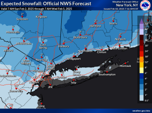
Several inches of accumulation is expected to the North with lighter amounts to the South. The potential amounts haven’t changed much with the latest computer guidance. The swaths can be over or under by an inch or so depending on mixing and where the heavy burst of snow materializes. Last call map is above. Sleet will accumulate with the snow making for treacherous conditions.
Any early Sunday morning light snow or mix will give way to mostly sunny skies. Readings will be seasonal in the upper 30s.
It’ll be a tranquil start to the week with high pressure building over our area.
Tuesday will feature another low moving up from the South. Any sun will give way to increasing clouds. Snow is possible later in the day and at night. Although the latest computer guidance suggests this system maybe to far to the South to affect our region with meaningful snowfall.
Wednesday at this time looks snow-free. A mix of clouds and some sun is expected.
Our rounds of snow and mixed precipitation may continue into late week.
Stay tuned.
Keep it here for a no nonsense, no hype forecast..
Saturday:
Sun to clouds. Snow/mix likely toward sunset. Highs in the mid 30s.
Tonight:
Heavy burst of snow for a couple of hours during the evening for most areas. Snow, mix, and rain depending on location tapers off around midnight. On and off light snow, mix, rain late tonight. Lows around 30º in the City, the mid to upper 20s inland. East to Northeast winds at 5-10mph.
Sunday:
Morning light snow/mix in spots, otherwise, becoming mostly sunny. Highs in the upper 30s.
Monday:
Sunny. Highs in the mid 30s.
Tuesday:
Sun to clouds. Low potential for snow later in the day. Highs in the mid 30s.
Wednesday:
More clouds than sun. Highs in the mid 30s.