
Synopsis:
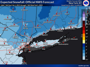
Today will feature any sunshine giving way to clouds as a Southerly flow develops as high pressure heads into the North Atlantic. A warm front will approach the Northeast later today and tonight. Scattered snow showers with a period of snow to the North is possible toward sunset and during the evening. This is expected mainly over the Northern one third of the region. Central and Southern NJ will not be in the zone. A coating of snow is possible with higher amounts to the North. The potential snow map is above. A bit of rain may fall to the East and along the coast. The precipitation will end shortly after midnight.
Monday will be milder with readings nearly ten degrees above the average high of the upper 30s.
Sunny and cooler conditions are expected for Tuesday as a cold front swings through in the morning.
On Wednesday weak low pressure will push from the Ohio Valley to the East coast. There maybe enough cold air for a bit of light snow or a mix to occur during the day. This is a low confidence forecast at this time as the computer models have not solidified on a solution. A mix to rain is likely Wednesday night into early Thursday.
Stay tuned.
Keep it here for a no nonsense, no hype forecast..
Sunday:
Sun to clouds. Chance of late day snow showers North. Highs in the mid 30s. East to Southeast winds at 5-10mph.
Tonight:
A period of snow well North this evening. Snow and or rain showers closer to the City. Becoming party cloudy late. Lows around freezing along the coast, the upper 20s inland. Southeast to Southwest winds at 5mph.
Monday:
Sun and clouds. Milder. Highs in the upper 40s.
Tuesday:
Sunny. Cooler. Highs in the lower 40s.
Wednesday:
Mostly cloudy. Potential for a bit of snow or mix. Highs in the mid to upper 30s.
Thursday:
AM mix inland to rain, rain at the coast. Mostly cloudy during the afternoon. Milder. Highs in the mid 40s.