Synopsis:
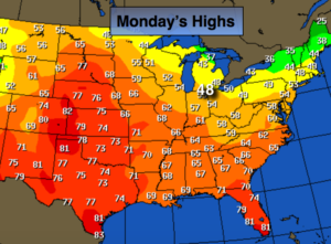
A warm Southerly flow will continue for the first half of the night ahead of a cold front. The cold front will be accompanied by a period of rain. Temperatures will fall dramatically before sunrise. The Spring Fling is over and it’s back to reality. This will be the start of the major pattern change to colder that will take hold for some time to come. Readings will be near average on Wednesday-the average high temperature is 46º, to below average through the weekend.
Will a storm form along the Eastern Seaboard? The latest computer guidance has a developing storm off the coast on Saturday. Morning snow showers are possible over coastal and Eastern areas. At this time a light accumulation seems slim at best at the coast. On Sunday an upper level disturbance will move through with the chance of flurries.
The jet stream will be be diving out of Canada and then turning up the coast. A more significant system may develop Tuesday or Wednesday of next week. How it all plays out is still anybody’s guess. One thing is for sure the cold is set in stone.
Stay tuned.
Tonight:
Showers. Warm to start with readings in the 50s. Temperatures will drop into the 40s in the City and the 30s inland once the front moves through late. South to West winds at 10-20mph with higher gusts.
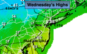
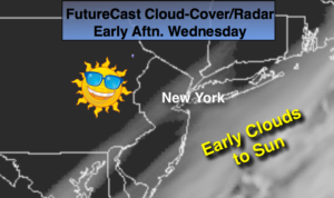
Wednesday:
Early clouds and showers East giving way to mostly sunny skies. Highs in the 40s. West winds at 10-20mph.
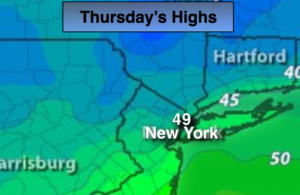
Thursday:
Partly sunny, colder. Highs in the mid 40s.
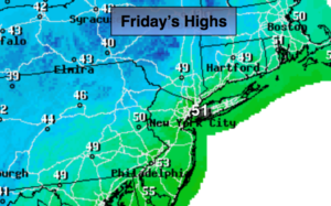
Friday:
Sun to clouds. Highs around 40º.
Saturday:
Clouds and sun. Scattered snow showers over Eastern areas in the morning. Highs in the upper 30s.
Sunday:
Clouds and sun. Scattered flurries. Highs in the upper 30s.
Keep it here for a no nonsense, no hype forecast.