Synopsis:
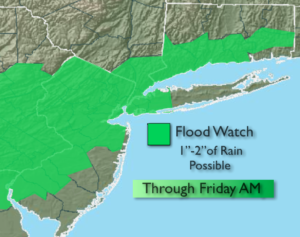
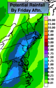
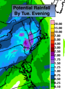
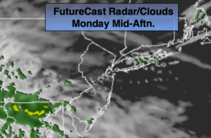
Many areas in the NYC vicinity today received between one and three inches of rain with locally higher amounts that led to flash flooding. The conveyor belt of moisture coming up from a tropical airmass will move offshore this evening. Local downpours in spots are expected through at least the beginning of the evening commute. Please be on the alert for flooded roadways. You never know how deep the water is. Turn around-don’t drown. High pressure over the Canadian maritimes along with a trough of low pressure moving along the East coast was the culprit. This pattern will break down tonight. Spotty showers or areas of drizzle and fog can be expected. It will be muggy.
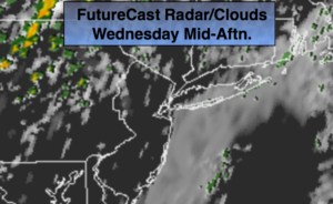
On Wednesday, a Southerly flow will keep the humidity high. Enough drying may occur for some sun from time to time. The majority of the day will be dry. A spot shower can’t be ruled out. A cool front will approach during the evening with scattered showers and possibly a thunderstorm.
Seasonal conditions are expected for the end of the week. A few morning showers are possible Friday, otherwise it should be fair.
The weekend looks bright with pleasant temperatures.
You know where to find a no hype, no nonsense forecast.
Stay tuned.
Tonight:
Scattered showers with locally heavy rain in spots through early evening, otherwise cloudy with patchy fog and areas of drizzle. Muggy. Lows around 70º in the City, the 60s inland. Southeast to Southwest less than 5mph..
Wednesday:
Clouds and some sun, warmer, more humid. A spot shower can’t be ruled out. The majority of the day will be dry. Scattered showers and a thunderstorm is possible during the evening. Highs near 80º. South winds at 8-12mph.
Thursday:
Partly sunny. Highs in the lower 70s.
Friday:
Scattered morning showers, otherwise a mix of clouds and sun. Highs in the lower 70s.
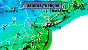
Saturday:
Mostly sunny. Highs in the lower to mid 70s.
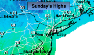
Sunday:
Sunny, cooler. Highs in the upper 60s.
Keep it here for a no nonsense, no hype forecast.