Synopsis:
Today the clouds and sun will battle it out, but the clouds will have the upper hand. It’ll be much cooler and less humid.
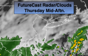
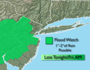
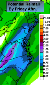
A ripple of low pressure will move up the coastal plain tonight and Friday. A period of rain is likely late tonight into Friday morning. Some of the rain maybe heavy, especially over Western areas. A Flood Watch has been posted for the potential of one to two inches of rain. The ground is already saturated so it won’t take much to cause streams, creeks and highways in flood prone areas to cause an issue. By Friday afternoon the rain will taper off and some late day sun is possible.
The weekend looks bright with pleasant temperatures as high pressure moves in from the Ohio Valley.
You know where to find a no hype, no nonsense forecast.
Stay tuned.
Today:
Clouds and some sun. Highs in the lower 70s. The average high is 71º. North to East winds at 8-12mph.
Tonight:
Rain developing during the late evening hours. The rain maybe heavy late. Lows in the 50s throughout. Winds East at 8-12mph.
Friday:
Morning rain, the rain maybe heavy early, some late day sun is possible. Highs in the mid to upper 60s.
Saturday:
Mostly sunny. Highs in the lower to mid 70s.
Sunday:
Sunny, cooler. Highs in the upper 60s.
Monday:
Mostly Sunny. Highs in the lower 70s.
Keep it here for a no nonsense, no hype forecast.