Synopsis:
Today will be cool as strong high pressure over Eastern Canada influences the area. Winds off the Atlantic will keep readings a several degrees below the average of 72º. Sun will dominate to the North while clouds will win the battle to the South of the City. A few spot showers are possible over parts of Ocean county.
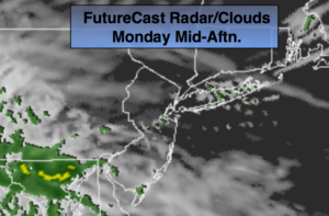
The High pressure over the Canadian maritimes along with a trough of low pressure moving toward the East coast will result in periods of rain tonight and Tuesday. The rain maybe heavy at times. By Wednesday, a cool front will approach the region with scattered showers and possibly a thunderstorm. There will be dry times on Wednesday.
Seasonal, pleasant conditions are expected for the end of the week.
You know where to find a no hype, no nonsense forecast.
Stay tuned.
Today:
Sun North, clouds South. Cool and breezy. Spotty showers over parts of Ocean County. Highs in the 60s to around 70º. Northeast to East winds at 15-25mph.
Tonight:
Light rain developing toward midnight. Lows around 60º in the City, the 50s inland. East winds at 15-25mph.
Tuesday:
Cloudy with periods of rain. The rain could be heavy at times. Highs in the lower 70s.
Wednesday:
Clouds and sun. Warmer and more humid with scattered showers and possibly a thunderstorm. Highs in the upper 70s.
Thursday:
Partly sunny. Highs in the lower 70s.
Friday:
Partly sunny. Highs in the lower 70s.
Keep it here for a no nonsense, no hype forecast.